July 25, 2006

The Big Here 02: What Time is Sunset Today?

This continues a series of ruminations, discussion on method, and answers to Kevin Kelly’s The Big Here, a query and challenge to know the space we live in, in its shape and relationships.

2) What time is sunset today?

One of the pleasures of living in the north half of the Northwest is the difference in the length of the days, from season to season. Not like Alaska, of course, but they might be taking things a little too far up there. Here, at least, the sun comes up every day. Still, a lot of people have trouble with those winter days when you go to work in the dark and come home after sunset. I’ll take that because it gives us these nights in midsummer when it’s still light enough to move around at 10:00.

I tend to notice the sunrise and set times throughout the year, though for reasons that vary with the seasons. During the late fall and early spring, I notice the change because it’s a qualitatively different experience to talk to and from work in the dark, as opposed to during the daylight. I spend as much time in the woods as I can, especially, but not exclusively during the late spring, summer, and early fall, and the amount of daylight matters for what I’m able to do. Because of this, I know that the latest sunset for Olympia is around 9:10, at midsummer. I also know that the sun sets at about 7:10 at the equinox (and we have just over twelve hours of daylight – “equi” indeed).

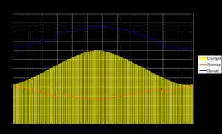
Until I started looking at this closer in preparation for writing this, I thought I could estimate the sunset for tonight using a simple proportion between those two times, which results in 8:25. The real answer is 8:53, because the change is not linear, but a curve. In the three months between the solstice and the equinox in September, the sunset changes about two hours, with 20 minutes in first month, 40 minutes in the next, and 60 minutes during the last. So, a new method would be to use the new proportions and say that we’re a little past that first month, which gives an estimate of about 8:50. Closer.

I learned this from the data that I pulled from the U.S. Naval Observatory’s Data Services site. And I built this chart from it. (Click on the image for a full size view.)

Chart of sunrise, sunset, and dayloght hours for Olympia, Wash. in 2006, with Daylight Savings Time
So, my new method for estimating sunset, at least for summer, is to determine how many months from the spring equinox we are and assign 20 minutes for the first (one-sixth of the 120 minutes change), 40 for the second (one-third of 120), and 60 for the third (or one-half of the total). I can use the same proportions for partial months. So, August 1 is about ten days into the second month, so it gets one-sixth of the second month’s 40 minutes, or 7 minutes. Subtracting 27 minutes from 9:11 results in 8:44, which is right on.

July 20, 2006

The Big Here 01: Point North

This begins the first of series of ruminations, discussion on method, and answers to Kevin Kelly’s The Big Here, a query and challenge to know the space we live in, in its shape and relationships.

1) Point north.

I have what I like to think of as a good sense of direction. I think I came about it naturally, but I’ve learned, through some disruptions, that what we call a sense of direction doesn’t just happen. It has to be grown and refreshed.

My original sense grew as a result of the strong environmental cues in where I grew up. Seattle has a regular grid of streets, with the avenues running north-south. It also has salt water to the west and fresh water to the east and distinct mountain ranges to the east and the west. As a result, direction was well-imprinted in my mind, even when I ventured over those bodies of water and into those mountains.

My complacency with regard to direction was shaken somewhat when I moved to the Bay Area for college. The street grids on the peninsula south of San Francisco were not laid out north and south. Everything was a little off, although I could maintain my general sense of which way was north, I carried a sketchier idea of directions for those months.

The next location I spent any time in was in west central Nebraska. That required more attention to rebuild my sense of direction. There was the river, but it didn’t take to much travel to leave it behind the last hill. And, north of town, the Sandhills spread for hundreds of square miles, with nary a directional cue, except the ever-present sun. So, I began to rely more on the sun as reinforcement to my sense of what direction was what.

I finally settled in Olympia which, though it’s near Seattle, has a different set of cues. Here, the water it to the north, I-5 runs east-west (at least north of Tumwater), and the mountains you can see are to the north. Just as with the other two examples of being out of directional sense, I remember the period where, in spite of the fairly regular street grid, I had some trouble rebuilding my sense of what direction is which way.

So, in answer to the question, I rely on my internal map of my local world to find north (or the other directions). It’s quite reliable, because I regularly refresh it with observation. That same process becomes, clearly, more important and explicit when I’m in a new place. The tools most useful to me in rebuilding my sense of direction are maps and observation.

Maps help me to understand the relationships of the major features in the area and help to identify the things I should look for as I move about. Topography is especially useful. On foot, especially, it’s hard to ignore whether you’re moving up or down and that can help you to know, if you’ve been able to gather that information, which direction you’re traveling in.

Observation is critical in three ways. It’s an important means of gathering information about the space I’m occupying. It serves as a means to integrate the information I collect through the visual observation. Most important, though, is that the observation itself actually builds my internal map. I can sketch out a place in my head by looking at a map, but it doesn’t become useful until I actually see the place.

In thinking about this question and reading the recommendations for this query, I noticed the mention of the analog watch method. I found a description of it in this WikiHow entry. Since I always have a watch and can usually tell where the sun is (we learn how to do that in the cloudy Pacific Northwest), it seems like a useful tool for recalibrating the internal map.

July 18, 2006

Beach Walk - Purdy Sand Spit

On a Saturday almost a month ago, my wife and a friend and I went on a beach walk at the Purdy Sand Spit, presented by a collection of local and state water quality agencies. The weather was terrific, the tide was -2.8’ at 11:08, and the beach was teeming. There were a good fifty people of all ages in attendance.

The guide for the walk was the local celebrity Alan Rammer, who is a Conservation Education Program Specialist with the Dept. of Fish and Wildlife, and who has spent thirty years or more walking the beaches of Washington and any place else near sea level and talking with people about the life that can be found there. He’s a local celebrity because he was the model for the character of the professor in Jim Lynch’s novel set in south Puget Sound, The Highest Tide. Lynch shadowed Rammer for a year while preparing the book.

So he started with a speech, well practiced and aimed at the kids in the group in expression, but also pointed at the adults, in which he described the beach as the living room of its inhabitants. His specific advice was to put everything back where you find it and make sure that you leave the rocks you overturn or pick up as you found them, right side up. I thought it was a nice touch.

We then headed down to the beach and looked around. Mr. Rammer knew the name and history of everything that anyone brought him, including the squid egg sacks and a deep-water fish that grows up in the shallows (forgot the name). We saw moon snails – they’re big! – and their egg sacks, which look like broken toilet plungers. There were sand crabs and rock crabs and hermit crabs, geoducks and horse clams and mussels, and sand dollars in stacks.

After the walk, we headed over the bridge to the Beach House, where we were treated to a local history exhibit and a nice lunch. Since we ate the lunch, we decided to stay for the talks after lunch. Lolling on the beach on a sunny afternoon in June is pleasant enough, even with a couple of talks about septic systems and water quality. The speakers were a Kitsap County Health District employee, Leslie Banigan, and Teri King, who works for the Washington Sea Grant Program.

It turned out to be quite excellent. I’ve always lived in houses that are connected to sewers, so I thought to learn a little about the effects of septic systems on water quality, but in a somewhat disconnected way. It wasn’t long into the presentations, however, before I realized that I am a septic system owner, at the Whidbey house. Damn. (At this point, I can visualize my mother rolling her eyes at my cluelessness. I’m slow on the uptake, but I remember once I get there.) So, I listened with new interest and learned a lot. I’ll have to find out more about the system we have out there at Whidbey, since it doesn’t get much of a workout and it’s perched right over the beach.

The whole thing, for free, was a great way to spend an early summer, sunny day: a little walk, a little beachcombing, a little lunch, a little sun, and a little learning. The whole thing was put together by Pierce Conservation District and the Puget Sound Action Team.

July 12, 2006

Messy Desk Contest

In response to Blue Wren’s challenge, here’s what on my desk, right now, besides an irregular, but noticeable layer of dust:

1. An older, but serviceable HP Deskjet 895Cse which needs a new color cartridge (it doesn’t print green anymore).

2. A Mountaineers Go Guide, July 2006 issue, and a stack of printouts (lacking in green) from the ConsumerReports.org Car Buying Kit (it’s a bit of a sore subject).

3. A stack of Grand Circle Travel (Small Ship Travel 2006, Travel Favorites 2006, and Europe 2006) catalogs my parents gave us. On top of that, a sheet of notes about airfare to Italy, which we’re visiting in October. That’s capped by my oldest nephew’s graduation announcement.

4. A small, wooden, decorated box with a very intricate inlaid top that my parents brought us from their last trip (on Grand Circle Travel) to the Middle East.

5. This computer’s monitor and speakers, which are usually turned off.

6. A plastic puzzle, which supposedly can be manipulated into a Rubic shape from its current misshapen, pointy blob of smaller cubes strung together with elastic. I’m beginning to think that I’ll never solve it.

7. A couple of note pads. Three Mountaineers release forms that I’m really supposed to send in. Three pens and a mechanical pencil. A white rock and a piece of green glass that I picked up off an Olympic National Park beach in the first weekend in July.

8. A stack of books, from the bottom:
Photoshop Elements 3, the Missing Manual edition (O’Reilly)
Mediterranean Europe on a Shoestring (Lonely Planet)
Venice (Lonely Planet)
Tuscany and Umbria (Frommer’s)
Pocket Rome (Fodor’s)
Rick Steve’s Italy 2006
Olympic Mountains Trail Guide (Mountaineers)
Backpacking Washington (Wilderness Press)
100 Hikes in Washington’s South Cascades and Olympics (Mountaineers)
Baedeker Rome (Macmillan Travel)

9. A Non Sequitur leaf-a-day calendar, with today’s offering titled “Birth of the Atkins-Shmatkins Rebellion.” Sometimes I don’t get Non Sequitur.

10. And, in the corner, a four-bin stacking file, which isn’t as full as it usually is. My stack, which is on top and often over-flows the top and will even, on occasion, spontaneously slide off into the paper recycling collection below it, is less than half full, though some of the items have been there a long time. On the bottom: a pamphlet from the Olympia Community Yoga Center titled Yoga Basics and a pretty goofy 8 x 10 of me in my friend’s boat. The next bin is my wife’s. It’s more full that mine, but less full than it usually is. I’ll leave its contents to her consideration. The bottom two are quite sparse – they were for my kids, but they’ve pretty much stopped getting mail here.

11. The odds and ends: a plastic coaster, an Oregon Shakespeare Festival bookmark, an extra mouse pad, and a small note with a list of things to remember to take to the beach house.

July 11, 2006

Lindens Blooming

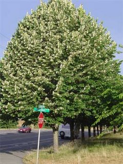
The linden trees lining the street next to my work building have started to bloom, filling the neighborhood with their deliciously sweet scent.
Linden Tree
The linden, also known as the lime or basswood tree, is famous in central Europe, where it appears in legends and poetry.

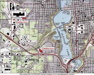
If only there were some way to send you the scent. Instead, I’ll show you a map with a few Olympia linden locations I’ve noticed over the last few weeks. I revised this on 7/20 with a little more detail and a few more trees.

July 10, 2006

Olympic NP Coast, South Segment

I spent the weekend before the Fourth of July backpacking the south segment of the Olympic National Park coastal trail, from Oil City on the north bank of the mouth of the Hoh River to Third Beach at La Push, on the south bank of the Quillayute River. Three days of sunny afternoons, sand and tides, and a unique wilderness coast. There were just two of us, Karen and I, from the Olympia Mountaineers who made the trip, but we were the lucky ones.

We started at the trailhead at Oil City (no city, the map has an “oil seep” marked a few miles away) on a trail that follows the Hoh River down to the ocean, where it drops you on the beach and a huge pile of driftwood, trapped between the river and ocean. A few miles of beach walking, with one small headland which we rounded on rocks, brought us to the first of the dreaded headland trails. We were fortunate: the weather had been dry for at least a week, so the trails were as non-muddy as they ever get, which is a particular blessing when climbing up the steep headland access trails.

The first headland climb, up to the trail passing Hoh Head, was a nice introduction to the tricks of this route. It consists of three cable ladders – wood steps suspended on cables about fifteen inches apart hanging down the steep slopes. The first two ladders came one after the other and were in fair shape. The last one was nasty – steep, slippery, and missing critical rungs at the top. Still, we topped it and climbed up to the top and through some pretty woods. There were lots of downed trees on this stretch – we even lost the trail to one for a time – but soon we were past Hoh Head and walking along the top of the bank with wonderful views of the ocean, its rocks and reefs, and beautiful, blue skies and water.

The old trail down to the beach just north of Hoh Head (which requires a quite low tide to continue north from there) was lost to a massive slide and we saw no sign of it at all. It wasn’t in our plans, anyway, because the tides that weekend were only moderate (low of one foot, high of nine feet), but were well-timed for midday. Late in the afternoon, we came across the first of the camps and descended to Mosquito Creek, where we camped. There were a small party camped in the woods, a couple camped on the beach, and, later, a group of seven hikers joined us for the night.

Crossing Mosquito Creek is one of the obstacles on this route, but presented no problems with the tide conditions and low water flow that we had. A pelagic cormorant rookery was established on the rock face of the headland to the south of our camp, with the long-necked birds constantly wheeling onto and off of the face. For a while, a falcon harassed them, but we didn’t see any other result.

The couple camped on the beach near us turned out to be Seattle Mountaineers and had noticed this hike listing, no doubt wondering how many backpackers I was going to bring them to crowd out their enjoyment. We spent part of the evening talking with them around their fire and then settled into our tents for the night.

The next morning our path took us up the beach for a couple of miles, over a headland with crossings of Goodman and Falls Creeks, and down to a camp on the beach at Toleak Point. The first beach stretch was slow going, because of the wonderful tide pool life amongst the big rocks and sea stacks left behind by the retreating tide. The trail up the bank south of Goodman Creek was better than Hoh Head’s, though the trail on top was much brushier. The creek crossings were easy, though I did manage to get water in one of my boots.

The trail down to the beach south of Toleak Point was an excellent cable ladder down solid rock. It seemed quite secure compared to some of what we’d seen. Just before we descended, we passed a couple going the other way with their golden retriever, which they’d loaded into a pack, emptied for the purpose, and carried up the ladder. (Pets aren’t allowed on the trail, but, you know, the rules don’t actually apply if you pretend to not know them or not see the hundreds of posted notices.)

There were five or six groups camped on the beach along the south side of Toleak Point and more camped in the woods on the west-facing beach north of the point. We started in the woods, but the wind was blowing right into them and the sun around the point made it feel fifteen degrees warmer, so we camped on the beach in the sun, nearer the only water. The tide came in from both sides of the point, making an interesting set of currents and flows as the two sides converged. Seals played in the water and eagles soared in the skies.

We were concerned about the group of just-short-of-middle-aged men who had sprawled their camp right on the only water source and in front of the trail to the privy. When we arrived they were drinking the biggest beers I’ve ever seen open and playing baseball on the beach. They followed this up with an enormous bonfire on the beach. Still, we were upwind and they ran out of gas early in the evening and were still getting up when we hiked out, so they weren’t a problem.

The final day offered a nice hike up the beach to Strawberry Point, where we saw more eagles and tide life, along another beach to another point which could be rounded on the rocks above the beach, to the camp at Scott Creek and the headland called Scotts Bluff. There was a large group camped there, right on the creek, as well. The trail on the south side of the Bluff was quite good – it climbed in a very civilized manner to the top, through some pretty woods – spruce and hemlock – to a very abrupt, steep clay slope, with ropes for assistance. I’m glad it was dry, for the footing was good. Wet would have been another experience.

The next leg was a short beach walk to the Taylor Point headland. The trail here was showing signs of nearing civilization. After a short scramble up a clay bank, it was solid stairs up the slope! This trail dropped back down to the beach over a couple of cable ladders in very good repair. And, then we were on Third Beach, which is well within reach of almost anyone, and it showed. There were lots of people on the beach, quite in contrast to our experience just over the last headland, and no wonder. It’s a beautiful beach, the weather was wonderful, and the parking lot is less than a mile and a half away.

We made short work of that last stretch, accompanied by the couple from Seattle, to whom we gave a ride into Forks. I’d had my car moved from Oil City by Rainforest Paddlers, who offer a shuttle service. To my delight, my car was there. To my credit, I had a set of keys in my pack, because I couldn’t find the keys that shuttlers had used to drive the car around. To the discredit of Rainforest Paddlers, when I called them to find out where my keys were, I learned that, instead of putting them in the trunk (I had a set in my pack, remember), under the mat, as I’d asked and as had been communicated to the shuttler, she decided to put them in the “usual” place, under the bumper. So, by the time I’d learned this, they had long since shaken loose. She called it a communications break-down, in spite of admitting that she’d received the communication fully. She just decided that she knew better. I call that an error in judgment. Fortunately for future trips to the coast, there is an alternative: Windsox Trailhead Shuttle.

Even that was nothing more than a minor irritation, given three days of sunny afternoons, dry weather, favorable tides, beautiful scenery, good company, interesting geography, topography, and wildlife.