My wife and I made our annual journey to the small town of Ashland, in southern Oregon, for a weekend of theater, good food, and relaxation. It works every time. The pattern is to drive down (about 400 miles straight down I-5) on a Thursday, see two plays a day on Friday through Sunday, and then drive back home on Monday. Every now and then we through in a visit to friends along the way or a Rogue River float trip or something, but that’s the basic plan.
The Oregon Shakespeare Festival has been operating there in Ashland for over 70 years. Their season runs from February to October and includes eleven plays in that time. The organization has three theaters: a large indoor theater, a small, flexible, indoor theater, and an outdoor, Elizabethan-style (well, except for the comfortable seats on the floor) stage. The company is permanent and quite stable, so you can see some of the same actors from year to year, which is quite a treat. I haven’t seen a bad performance in ten years.
On Friday afternoon, we saw the history, King John, which was played on a simple, but effective stage, so our focus was on the characters, nearly all of whom were embedded in an environment of greed, ambition, deceit, and violence. It was a marvelously cynical world, in which the echoes of our own time were too apparent. (There was a line bemoaning the poor intelligence that allowed the French army to land on English soil without warning that brought a hiss of recognition from the audience. Nothing but Shakespeare's words.)
At dinner after the show, there was a discussion at the next table about who was the “moral center” of the play. I'm not sure what their idea of what that concept means, but I couldn't see any of their candidates as the “moral center.” Every character was motivated by some ambition for power or money or both. The Bastard was willing to abandon anyone or anything for gain and served as a constant voice for violence. Toward the end he even began to horrify the other, equally venal characters. The only human-seeming character (other than the pawn, Arthur), was the simpler man, Hubert, who struggled to keep his head and his heart above the fray, as others sought to use him for their purposes.
Friday evening’s play was The Merry Wives of Windsor, staged on a very tarted-up Elizabethan stage with extravagantly bizarre costumes. This company knows how to pull the comedy out of the Bard's words, no doubt about it. There was slapstick, shameless mugging, and hilarious malapropisms. Quite a romp.
Saturday’s plays were a couple of my favorites: The Importance of Being Earnest in the Angus Bowmer Theater and Cyrano De Bergerac in the Elizabethan Theater. The company puts so much into their comedies. I don’t think I’ve enjoyed comedy more anywhere else. As expected, they did a wonderful job with the Earnest.
I was a little disappointed with the Cyrano. I’ve loved the play since I read it in school and I was very much looking forward to a fine, robust performance on the Elizabethan stage. Unfortunately, the understudy was in the title role and, while we’ve seen this actor do marvelous things in other performances and he knew his lines, he wasn’t able to bring the necessary panache to the role. Neither in physical presence nor in his voice was he the dominant figure that the role requires.
On Sunday afternoon, we saw a very interesting David Edgar play, Dr. Jekyll and Mr. Hyde. As I watched it, I realized that, although I knew the outlines of the story (who doesn’t), I didn’t know how it ended. I don’t think I’ve read the original. Anyway, the play is an adaptation of the original, and the several other adaptations made along the way, and it is a psychologically complex and insightful work. The set was a marvel of complexity made simple and the actor playing the lead did a terrific job with the dual role: a shrinking, diffident, troubled Jekyll and a brutal, aggressive – trouble – Hyde.
The closing play was Two Gentlemen of Verona, in the Elizabethan Theater. The play involves the conflicts and opportunities that arise from leaving the place in which one has grown up and formed one’s values and going to another place, where those values are put to the test. In this presentation, they set “Verona” in a conservative, collective kind of community modeled something after the Amish and the like, while the other place is rich, hedonistic, and looked something like the Hamptons (not that I’ve ever been there). It was an interesting way to make the environments in which the conflicts occur clear.
This performance was interesting in another way, which was a first for us in Ashland. As we were eating dinner before the performance, I looked out the window and noticed that the street trees were swaying vigorously and wondered if that meant rain. Sure enough, within a couple of seconds, someone walked by under an umbrella. It was raining and the theater was wet when we arrived, being open to the sky. The heavy rain had quit by then, but showers still threatened, so we bought a couple of plastic ponchos, which the concessionaires were selling like, well, umbrellas. If one likes, in the event of rain, one may get a refund, as long as one asks for it early enough. I saw only one couple leave. It really didn’t rain enough to worry about, once the play began.
I’m ready to go again next year, already. There’s an interesting line-up, including Checkov’s The Cherry Orchard, On the Razzle by Tom Stoppard (a favorite of mine), August Wilson’s Gem of the Ocean, and Shakespeare’s The Tempest.
August 10, 2006


August 4, 2006
Meta: Remote Blogging
I'm writing this from the public library in Ashland, Oregon, where my wife and I have made our annual pilgrimage to the Oregon Shakespeare Festival. We'll have our usual grueling theatrical two-a-days, interspersed with good meals and other lounging-about-type activities.
I've not blogged from the road before. A lot of the trips we make are not well suited to taking the time to do this. Either that or there is no possibility at all, such as when I'm off the grid (thankfully) on a hike or on a small boat. This trip offers more chances, though the clock is ticking on my 30 minutes here in the library. (So, I'm going to focus on the text and will come back later for an update and some prettying-up. Accomplished 8/13/06.)
I find it hard to write well about a trip after it is over. You can see some evidence of this from the abortive attempt to write about our January British Virgin Islands trip. Still, there is some advantage to writing after the event, for the perspective that reflection brings. Unfortunately, the energy the trip brings wanes once I've been plunged back into the workaday routine. So, we'll see what immediacy brings.
We drove straight down I-5 for almost 400 miles without mishap yesterday. Made it on one tank of gas, too, thanks to Prius. It's warm, even hot, with temperatures in the low 90's predicted for the weekend. There's a bit of a breeze and the air is dry, so it's not oppressive. We wandered around town a little this morning, making dinner plans and talking about what we want to do over the next few days. This activity is my plan for the morning and early afternoon. Then, we'll have a matinee of King John in the New Theater.
Thirty minutes is up...
I've not blogged from the road before. A lot of the trips we make are not well suited to taking the time to do this. Either that or there is no possibility at all, such as when I'm off the grid (thankfully) on a hike or on a small boat. This trip offers more chances, though the clock is ticking on my 30 minutes here in the library. (So, I'm going to focus on the text and will come back later for an update and some prettying-up. Accomplished 8/13/06.)
I find it hard to write well about a trip after it is over. You can see some evidence of this from the abortive attempt to write about our January British Virgin Islands trip. Still, there is some advantage to writing after the event, for the perspective that reflection brings. Unfortunately, the energy the trip brings wanes once I've been plunged back into the workaday routine. So, we'll see what immediacy brings.
We drove straight down I-5 for almost 400 miles without mishap yesterday. Made it on one tank of gas, too, thanks to Prius. It's warm, even hot, with temperatures in the low 90's predicted for the weekend. There's a bit of a breeze and the air is dry, so it's not oppressive. We wandered around town a little this morning, making dinner plans and talking about what we want to do over the next few days. This activity is my plan for the morning and early afternoon. Then, we'll have a matinee of King John in the New Theater.
Thirty minutes is up...
July 25, 2006
The Big Here 02: What Time is Sunset Today?
This continues a series of ruminations, discussion on method, and answers to Kevin Kelly’s The Big Here, a query and challenge to know the space we live in, in its shape and relationships.
2) What time is sunset today?
One of the pleasures of living in the north half of the Northwest is the difference in the length of the days, from season to season. Not like Alaska, of course, but they might be taking things a little too far up there. Here, at least, the sun comes up every day. Still, a lot of people have trouble with those winter days when you go to work in the dark and come home after sunset. I’ll take that because it gives us these nights in midsummer when it’s still light enough to move around at 10:00.
I tend to notice the sunrise and set times throughout the year, though for reasons that vary with the seasons. During the late fall and early spring, I notice the change because it’s a qualitatively different experience to talk to and from work in the dark, as opposed to during the daylight. I spend as much time in the woods as I can, especially, but not exclusively during the late spring, summer, and early fall, and the amount of daylight matters for what I’m able to do. Because of this, I know that the latest sunset for Olympia is around 9:10, at midsummer. I also know that the sun sets at about 7:10 at the equinox (and we have just over twelve hours of daylight – “equi” indeed).
Until I started looking at this closer in preparation for writing this, I thought I could estimate the sunset for tonight using a simple proportion between those two times, which results in 8:25. The real answer is 8:53, because the change is not linear, but a curve. In the three months between the solstice and the equinox in September, the sunset changes about two hours, with 20 minutes in first month, 40 minutes in the next, and 60 minutes during the last. So, a new method would be to use the new proportions and say that we’re a little past that first month, which gives an estimate of about 8:50. Closer.
I learned this from the data that I pulled from the U.S. Naval Observatory’s Data Services site. And I built this chart from it. (Click on the image for a full size view.)
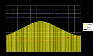
So, my new method for estimating sunset, at least for summer, is to determine how many months from the spring equinox we are and assign 20 minutes for the first (one-sixth of the 120 minutes change), 40 for the second (one-third of 120), and 60 for the third (or one-half of the total). I can use the same proportions for partial months. So, August 1 is about ten days into the second month, so it gets one-sixth of the second month’s 40 minutes, or 7 minutes. Subtracting 27 minutes from 9:11 results in 8:44, which is right on.
2) What time is sunset today?
One of the pleasures of living in the north half of the Northwest is the difference in the length of the days, from season to season. Not like Alaska, of course, but they might be taking things a little too far up there. Here, at least, the sun comes up every day. Still, a lot of people have trouble with those winter days when you go to work in the dark and come home after sunset. I’ll take that because it gives us these nights in midsummer when it’s still light enough to move around at 10:00.
I tend to notice the sunrise and set times throughout the year, though for reasons that vary with the seasons. During the late fall and early spring, I notice the change because it’s a qualitatively different experience to talk to and from work in the dark, as opposed to during the daylight. I spend as much time in the woods as I can, especially, but not exclusively during the late spring, summer, and early fall, and the amount of daylight matters for what I’m able to do. Because of this, I know that the latest sunset for Olympia is around 9:10, at midsummer. I also know that the sun sets at about 7:10 at the equinox (and we have just over twelve hours of daylight – “equi” indeed).
Until I started looking at this closer in preparation for writing this, I thought I could estimate the sunset for tonight using a simple proportion between those two times, which results in 8:25. The real answer is 8:53, because the change is not linear, but a curve. In the three months between the solstice and the equinox in September, the sunset changes about two hours, with 20 minutes in first month, 40 minutes in the next, and 60 minutes during the last. So, a new method would be to use the new proportions and say that we’re a little past that first month, which gives an estimate of about 8:50. Closer.
I learned this from the data that I pulled from the U.S. Naval Observatory’s Data Services site. And I built this chart from it. (Click on the image for a full size view.)

So, my new method for estimating sunset, at least for summer, is to determine how many months from the spring equinox we are and assign 20 minutes for the first (one-sixth of the 120 minutes change), 40 for the second (one-third of 120), and 60 for the third (or one-half of the total). I can use the same proportions for partial months. So, August 1 is about ten days into the second month, so it gets one-sixth of the second month’s 40 minutes, or 7 minutes. Subtracting 27 minutes from 9:11 results in 8:44, which is right on.
July 20, 2006
The Big Here 01: Point North
This begins the first of series of ruminations, discussion on method, and answers to Kevin Kelly’s The Big Here, a query and challenge to know the space we live in, in its shape and relationships.
1) Point north.
I have what I like to think of as a good sense of direction. I think I came about it naturally, but I’ve learned, through some disruptions, that what we call a sense of direction doesn’t just happen. It has to be grown and refreshed.
My original sense grew as a result of the strong environmental cues in where I grew up. Seattle has a regular grid of streets, with the avenues running north-south. It also has salt water to the west and fresh water to the east and distinct mountain ranges to the east and the west. As a result, direction was well-imprinted in my mind, even when I ventured over those bodies of water and into those mountains.
My complacency with regard to direction was shaken somewhat when I moved to the Bay Area for college. The street grids on the peninsula south of San Francisco were not laid out north and south. Everything was a little off, although I could maintain my general sense of which way was north, I carried a sketchier idea of directions for those months.
The next location I spent any time in was in west central Nebraska. That required more attention to rebuild my sense of direction. There was the river, but it didn’t take to much travel to leave it behind the last hill. And, north of town, the Sandhills spread for hundreds of square miles, with nary a directional cue, except the ever-present sun. So, I began to rely more on the sun as reinforcement to my sense of what direction was what.
I finally settled in Olympia which, though it’s near Seattle, has a different set of cues. Here, the water it to the north, I-5 runs east-west (at least north of Tumwater), and the mountains you can see are to the north. Just as with the other two examples of being out of directional sense, I remember the period where, in spite of the fairly regular street grid, I had some trouble rebuilding my sense of what direction is which way.
So, in answer to the question, I rely on my internal map of my local world to find north (or the other directions). It’s quite reliable, because I regularly refresh it with observation. That same process becomes, clearly, more important and explicit when I’m in a new place. The tools most useful to me in rebuilding my sense of direction are maps and observation.
Maps help me to understand the relationships of the major features in the area and help to identify the things I should look for as I move about. Topography is especially useful. On foot, especially, it’s hard to ignore whether you’re moving up or down and that can help you to know, if you’ve been able to gather that information, which direction you’re traveling in.
Observation is critical in three ways. It’s an important means of gathering information about the space I’m occupying. It serves as a means to integrate the information I collect through the visual observation. Most important, though, is that the observation itself actually builds my internal map. I can sketch out a place in my head by looking at a map, but it doesn’t become useful until I actually see the place.
In thinking about this question and reading the recommendations for this query, I noticed the mention of the analog watch method. I found a description of it in this WikiHow entry. Since I always have a watch and can usually tell where the sun is (we learn how to do that in the cloudy Pacific Northwest), it seems like a useful tool for recalibrating the internal map.
1) Point north.
I have what I like to think of as a good sense of direction. I think I came about it naturally, but I’ve learned, through some disruptions, that what we call a sense of direction doesn’t just happen. It has to be grown and refreshed.
My original sense grew as a result of the strong environmental cues in where I grew up. Seattle has a regular grid of streets, with the avenues running north-south. It also has salt water to the west and fresh water to the east and distinct mountain ranges to the east and the west. As a result, direction was well-imprinted in my mind, even when I ventured over those bodies of water and into those mountains.
My complacency with regard to direction was shaken somewhat when I moved to the Bay Area for college. The street grids on the peninsula south of San Francisco were not laid out north and south. Everything was a little off, although I could maintain my general sense of which way was north, I carried a sketchier idea of directions for those months.
The next location I spent any time in was in west central Nebraska. That required more attention to rebuild my sense of direction. There was the river, but it didn’t take to much travel to leave it behind the last hill. And, north of town, the Sandhills spread for hundreds of square miles, with nary a directional cue, except the ever-present sun. So, I began to rely more on the sun as reinforcement to my sense of what direction was what.
I finally settled in Olympia which, though it’s near Seattle, has a different set of cues. Here, the water it to the north, I-5 runs east-west (at least north of Tumwater), and the mountains you can see are to the north. Just as with the other two examples of being out of directional sense, I remember the period where, in spite of the fairly regular street grid, I had some trouble rebuilding my sense of what direction is which way.
So, in answer to the question, I rely on my internal map of my local world to find north (or the other directions). It’s quite reliable, because I regularly refresh it with observation. That same process becomes, clearly, more important and explicit when I’m in a new place. The tools most useful to me in rebuilding my sense of direction are maps and observation.
Maps help me to understand the relationships of the major features in the area and help to identify the things I should look for as I move about. Topography is especially useful. On foot, especially, it’s hard to ignore whether you’re moving up or down and that can help you to know, if you’ve been able to gather that information, which direction you’re traveling in.
Observation is critical in three ways. It’s an important means of gathering information about the space I’m occupying. It serves as a means to integrate the information I collect through the visual observation. Most important, though, is that the observation itself actually builds my internal map. I can sketch out a place in my head by looking at a map, but it doesn’t become useful until I actually see the place.
In thinking about this question and reading the recommendations for this query, I noticed the mention of the analog watch method. I found a description of it in this WikiHow entry. Since I always have a watch and can usually tell where the sun is (we learn how to do that in the cloudy Pacific Northwest), it seems like a useful tool for recalibrating the internal map.
July 18, 2006
Beach Walk - Purdy Sand Spit
On a Saturday almost a month ago, my wife and a friend and I went on a beach walk at the Purdy Sand Spit, presented by a collection of local and state water quality agencies. The weather was terrific, the tide was -2.8’ at 11:08, and the beach was teeming. There were a good fifty people of all ages in attendance.
The guide for the walk was the local celebrity Alan Rammer, who is a Conservation Education Program Specialist with the Dept. of Fish and Wildlife, and who has spent thirty years or more walking the beaches of Washington and any place else near sea level and talking with people about the life that can be found there. He’s a local celebrity because he was the model for the character of the professor in Jim Lynch’s novel set in south Puget Sound, The Highest Tide. Lynch shadowed Rammer for a year while preparing the book.
So he started with a speech, well practiced and aimed at the kids in the group in expression, but also pointed at the adults, in which he described the beach as the living room of its inhabitants. His specific advice was to put everything back where you find it and make sure that you leave the rocks you overturn or pick up as you found them, right side up. I thought it was a nice touch.
We then headed down to the beach and looked around. Mr. Rammer knew the name and history of everything that anyone brought him, including the squid egg sacks and a deep-water fish that grows up in the shallows (forgot the name). We saw moon snails – they’re big! – and their egg sacks, which look like broken toilet plungers. There were sand crabs and rock crabs and hermit crabs, geoducks and horse clams and mussels, and sand dollars in stacks.
After the walk, we headed over the bridge to the Beach House, where we were treated to a local history exhibit and a nice lunch. Since we ate the lunch, we decided to stay for the talks after lunch. Lolling on the beach on a sunny afternoon in June is pleasant enough, even with a couple of talks about septic systems and water quality. The speakers were a Kitsap County Health District employee, Leslie Banigan, and Teri King, who works for the Washington Sea Grant Program.
It turned out to be quite excellent. I’ve always lived in houses that are connected to sewers, so I thought to learn a little about the effects of septic systems on water quality, but in a somewhat disconnected way. It wasn’t long into the presentations, however, before I realized that I am a septic system owner, at the Whidbey house. Damn. (At this point, I can visualize my mother rolling her eyes at my cluelessness. I’m slow on the uptake, but I remember once I get there.) So, I listened with new interest and learned a lot. I’ll have to find out more about the system we have out there at Whidbey, since it doesn’t get much of a workout and it’s perched right over the beach.
The whole thing, for free, was a great way to spend an early summer, sunny day: a little walk, a little beachcombing, a little lunch, a little sun, and a little learning. The whole thing was put together by Pierce Conservation District and the Puget Sound Action Team.
The guide for the walk was the local celebrity Alan Rammer, who is a Conservation Education Program Specialist with the Dept. of Fish and Wildlife, and who has spent thirty years or more walking the beaches of Washington and any place else near sea level and talking with people about the life that can be found there. He’s a local celebrity because he was the model for the character of the professor in Jim Lynch’s novel set in south Puget Sound, The Highest Tide. Lynch shadowed Rammer for a year while preparing the book.
So he started with a speech, well practiced and aimed at the kids in the group in expression, but also pointed at the adults, in which he described the beach as the living room of its inhabitants. His specific advice was to put everything back where you find it and make sure that you leave the rocks you overturn or pick up as you found them, right side up. I thought it was a nice touch.
We then headed down to the beach and looked around. Mr. Rammer knew the name and history of everything that anyone brought him, including the squid egg sacks and a deep-water fish that grows up in the shallows (forgot the name). We saw moon snails – they’re big! – and their egg sacks, which look like broken toilet plungers. There were sand crabs and rock crabs and hermit crabs, geoducks and horse clams and mussels, and sand dollars in stacks.

After the walk, we headed over the bridge to the Beach House, where we were treated to a local history exhibit and a nice lunch. Since we ate the lunch, we decided to stay for the talks after lunch. Lolling on the beach on a sunny afternoon in June is pleasant enough, even with a couple of talks about septic systems and water quality. The speakers were a Kitsap County Health District employee, Leslie Banigan, and Teri King, who works for the Washington Sea Grant Program.
It turned out to be quite excellent. I’ve always lived in houses that are connected to sewers, so I thought to learn a little about the effects of septic systems on water quality, but in a somewhat disconnected way. It wasn’t long into the presentations, however, before I realized that I am a septic system owner, at the Whidbey house. Damn. (At this point, I can visualize my mother rolling her eyes at my cluelessness. I’m slow on the uptake, but I remember once I get there.) So, I listened with new interest and learned a lot. I’ll have to find out more about the system we have out there at Whidbey, since it doesn’t get much of a workout and it’s perched right over the beach.
The whole thing, for free, was a great way to spend an early summer, sunny day: a little walk, a little beachcombing, a little lunch, a little sun, and a little learning. The whole thing was put together by Pierce Conservation District and the Puget Sound Action Team.
July 12, 2006
Messy Desk Contest
In response to Blue Wren’s challenge, here’s what on my desk, right now, besides an irregular, but noticeable layer of dust:
1. An older, but serviceable HP Deskjet 895Cse which needs a new color cartridge (it doesn’t print green anymore).
2. A Mountaineers Go Guide, July 2006 issue, and a stack of printouts (lacking in green) from the ConsumerReports.org Car Buying Kit (it’s a bit of a sore subject).
3. A stack of Grand Circle Travel (Small Ship Travel 2006, Travel Favorites 2006, and Europe 2006) catalogs my parents gave us. On top of that, a sheet of notes about airfare to Italy, which we’re visiting in October. That’s capped by my oldest nephew’s graduation announcement.
4. A small, wooden, decorated box with a very intricate inlaid top that my parents brought us from their last trip (on Grand Circle Travel) to the Middle East.
5. This computer’s monitor and speakers, which are usually turned off.
6. A plastic puzzle, which supposedly can be manipulated into a Rubic shape from its current misshapen, pointy blob of smaller cubes strung together with elastic. I’m beginning to think that I’ll never solve it.
7. A couple of note pads. Three Mountaineers release forms that I’m really supposed to send in. Three pens and a mechanical pencil. A white rock and a piece of green glass that I picked up off an Olympic National Park beach in the first weekend in July.
8. A stack of books, from the bottom:
Photoshop Elements 3, the Missing Manual edition (O’Reilly)
Mediterranean Europe on a Shoestring (Lonely Planet)
Venice (Lonely Planet)
Tuscany and Umbria (Frommer’s)
Pocket Rome (Fodor’s)
Rick Steve’s Italy 2006
Olympic Mountains Trail Guide (Mountaineers)
Backpacking Washington (Wilderness Press)
100 Hikes in Washington’s South Cascades and Olympics (Mountaineers)
Baedeker Rome (Macmillan Travel)
9. A Non Sequitur leaf-a-day calendar, with today’s offering titled “Birth of the Atkins-Shmatkins Rebellion.” Sometimes I don’t get Non Sequitur.
10. And, in the corner, a four-bin stacking file, which isn’t as full as it usually is. My stack, which is on top and often over-flows the top and will even, on occasion, spontaneously slide off into the paper recycling collection below it, is less than half full, though some of the items have been there a long time. On the bottom: a pamphlet from the Olympia Community Yoga Center titled Yoga Basics and a pretty goofy 8 x 10 of me in my friend’s boat. The next bin is my wife’s. It’s more full that mine, but less full than it usually is. I’ll leave its contents to her consideration. The bottom two are quite sparse – they were for my kids, but they’ve pretty much stopped getting mail here.
11. The odds and ends: a plastic coaster, an Oregon Shakespeare Festival bookmark, an extra mouse pad, and a small note with a list of things to remember to take to the beach house.
1. An older, but serviceable HP Deskjet 895Cse which needs a new color cartridge (it doesn’t print green anymore).
2. A Mountaineers Go Guide, July 2006 issue, and a stack of printouts (lacking in green) from the ConsumerReports.org Car Buying Kit (it’s a bit of a sore subject).
3. A stack of Grand Circle Travel (Small Ship Travel 2006, Travel Favorites 2006, and Europe 2006) catalogs my parents gave us. On top of that, a sheet of notes about airfare to Italy, which we’re visiting in October. That’s capped by my oldest nephew’s graduation announcement.
4. A small, wooden, decorated box with a very intricate inlaid top that my parents brought us from their last trip (on Grand Circle Travel) to the Middle East.
5. This computer’s monitor and speakers, which are usually turned off.
6. A plastic puzzle, which supposedly can be manipulated into a Rubic shape from its current misshapen, pointy blob of smaller cubes strung together with elastic. I’m beginning to think that I’ll never solve it.
7. A couple of note pads. Three Mountaineers release forms that I’m really supposed to send in. Three pens and a mechanical pencil. A white rock and a piece of green glass that I picked up off an Olympic National Park beach in the first weekend in July.
8. A stack of books, from the bottom:
Photoshop Elements 3, the Missing Manual edition (O’Reilly)
Mediterranean Europe on a Shoestring (Lonely Planet)
Venice (Lonely Planet)
Tuscany and Umbria (Frommer’s)
Pocket Rome (Fodor’s)
Rick Steve’s Italy 2006
Olympic Mountains Trail Guide (Mountaineers)
Backpacking Washington (Wilderness Press)
100 Hikes in Washington’s South Cascades and Olympics (Mountaineers)
Baedeker Rome (Macmillan Travel)
9. A Non Sequitur leaf-a-day calendar, with today’s offering titled “Birth of the Atkins-Shmatkins Rebellion.” Sometimes I don’t get Non Sequitur.
10. And, in the corner, a four-bin stacking file, which isn’t as full as it usually is. My stack, which is on top and often over-flows the top and will even, on occasion, spontaneously slide off into the paper recycling collection below it, is less than half full, though some of the items have been there a long time. On the bottom: a pamphlet from the Olympia Community Yoga Center titled Yoga Basics and a pretty goofy 8 x 10 of me in my friend’s boat. The next bin is my wife’s. It’s more full that mine, but less full than it usually is. I’ll leave its contents to her consideration. The bottom two are quite sparse – they were for my kids, but they’ve pretty much stopped getting mail here.
11. The odds and ends: a plastic coaster, an Oregon Shakespeare Festival bookmark, an extra mouse pad, and a small note with a list of things to remember to take to the beach house.
July 11, 2006
Lindens Blooming
The linden trees lining the street next to my work building have started to bloom, filling the neighborhood with their deliciously sweet scent.
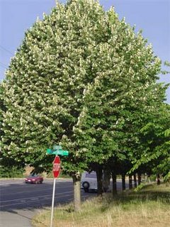
The linden, also known as the lime or basswood tree, is famous in central Europe, where it appears in legends and poetry.
If only there were some way to send you the scent. Instead, I’ll show you a map with a few Olympia linden locations I’ve noticed over the last few weeks. I revised this on 7/20 with a little more detail and a few more trees.
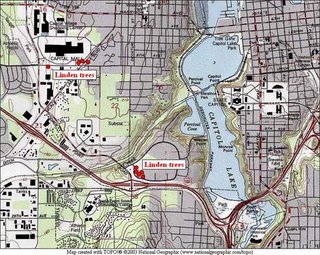

The linden, also known as the lime or basswood tree, is famous in central Europe, where it appears in legends and poetry.
If only there were some way to send you the scent. Instead, I’ll show you a map with a few Olympia linden locations I’ve noticed over the last few weeks. I revised this on 7/20 with a little more detail and a few more trees.

July 10, 2006
Olympic NP Coast, South Segment
I spent the weekend before the Fourth of July backpacking the south segment of the Olympic National Park coastal trail, from Oil City on the north bank of the mouth of the Hoh River to Third Beach at La Push, on the south bank of the Quillayute River. Three days of sunny afternoons, sand and tides, and a unique wilderness coast. There were just two of us, Karen and I, from the Olympia Mountaineers who made the trip, but we were the lucky ones.
We started at the trailhead at Oil City (no city, the map has an “oil seep” marked a few miles away) on a trail that follows the Hoh River down to the ocean, where it drops you on the beach and a huge pile of driftwood, trapped between the river and ocean. A few miles of beach walking, with one small headland which we rounded on rocks, brought us to the first of the dreaded headland trails. We were fortunate: the weather had been dry for at least a week, so the trails were as non-muddy as they ever get, which is a particular blessing when climbing up the steep headland access trails.
The first headland climb, up to the trail passing Hoh Head, was a nice introduction to the tricks of this route. It consists of three cable ladders – wood steps suspended on cables about fifteen inches apart hanging down the steep slopes. The first two ladders came one after the other and were in fair shape. The last one was nasty – steep, slippery, and missing critical rungs at the top. Still, we topped it and climbed up to the top and through some pretty woods. There were lots of downed trees on this stretch – we even lost the trail to one for a time – but soon we were past Hoh Head and walking along the top of the bank with wonderful views of the ocean, its rocks and reefs, and beautiful, blue skies and water.
The old trail down to the beach just north of Hoh Head (which requires a quite low tide to continue north from there) was lost to a massive slide and we saw no sign of it at all. It wasn’t in our plans, anyway, because the tides that weekend were only moderate (low of one foot, high of nine feet), but were well-timed for midday. Late in the afternoon, we came across the first of the camps and descended to Mosquito Creek, where we camped. There were a small party camped in the woods, a couple camped on the beach, and, later, a group of seven hikers joined us for the night.
Crossing Mosquito Creek is one of the obstacles on this route, but presented no problems with the tide conditions and low water flow that we had. A pelagic cormorant rookery was established on the rock face of the headland to the south of our camp, with the long-necked birds constantly wheeling onto and off of the face. For a while, a falcon harassed them, but we didn’t see any other result.
The couple camped on the beach near us turned out to be Seattle Mountaineers and had noticed this hike listing, no doubt wondering how many backpackers I was going to bring them to crowd out their enjoyment. We spent part of the evening talking with them around their fire and then settled into our tents for the night.
The next morning our path took us up the beach for a couple of miles, over a headland with crossings of Goodman and Falls Creeks, and down to a camp on the beach at Toleak Point. The first beach stretch was slow going, because of the wonderful tide pool life amongst the big rocks and sea stacks left behind by the retreating tide. The trail up the bank south of Goodman Creek was better than Hoh Head’s, though the trail on top was much brushier. The creek crossings were easy, though I did manage to get water in one of my boots.
The trail down to the beach south of Toleak Point was an excellent cable ladder down solid rock. It seemed quite secure compared to some of what we’d seen. Just before we descended, we passed a couple going the other way with their golden retriever, which they’d loaded into a pack, emptied for the purpose, and carried up the ladder. (Pets aren’t allowed on the trail, but, you know, the rules don’t actually apply if you pretend to not know them or not see the hundreds of posted notices.)
There were five or six groups camped on the beach along the south side of Toleak Point and more camped in the woods on the west-facing beach north of the point. We started in the woods, but the wind was blowing right into them and the sun around the point made it feel fifteen degrees warmer, so we camped on the beach in the sun, nearer the only water. The tide came in from both sides of the point, making an interesting set of currents and flows as the two sides converged. Seals played in the water and eagles soared in the skies.
We were concerned about the group of just-short-of-middle-aged men who had sprawled their camp right on the only water source and in front of the trail to the privy. When we arrived they were drinking the biggest beers I’ve ever seen open and playing baseball on the beach. They followed this up with an enormous bonfire on the beach. Still, we were upwind and they ran out of gas early in the evening and were still getting up when we hiked out, so they weren’t a problem.
The final day offered a nice hike up the beach to Strawberry Point, where we saw more eagles and tide life, along another beach to another point which could be rounded on the rocks above the beach, to the camp at Scott Creek and the headland called Scotts Bluff. There was a large group camped there, right on the creek, as well. The trail on the south side of the Bluff was quite good – it climbed in a very civilized manner to the top, through some pretty woods – spruce and hemlock – to a very abrupt, steep clay slope, with ropes for assistance. I’m glad it was dry, for the footing was good. Wet would have been another experience.
The next leg was a short beach walk to the Taylor Point headland. The trail here was showing signs of nearing civilization. After a short scramble up a clay bank, it was solid stairs up the slope! This trail dropped back down to the beach over a couple of cable ladders in very good repair. And, then we were on Third Beach, which is well within reach of almost anyone, and it showed. There were lots of people on the beach, quite in contrast to our experience just over the last headland, and no wonder. It’s a beautiful beach, the weather was wonderful, and the parking lot is less than a mile and a half away.
We made short work of that last stretch, accompanied by the couple from Seattle, to whom we gave a ride into Forks. I’d had my car moved from Oil City by Rainforest Paddlers, who offer a shuttle service. To my delight, my car was there. To my credit, I had a set of keys in my pack, because I couldn’t find the keys that shuttlers had used to drive the car around. To the discredit of Rainforest Paddlers, when I called them to find out where my keys were, I learned that, instead of putting them in the trunk (I had a set in my pack, remember), under the mat, as I’d asked and as had been communicated to the shuttler, she decided to put them in the “usual” place, under the bumper. So, by the time I’d learned this, they had long since shaken loose. She called it a communications break-down, in spite of admitting that she’d received the communication fully. She just decided that she knew better. I call that an error in judgment. Fortunately for future trips to the coast, there is an alternative: Windsox Trailhead Shuttle.
Even that was nothing more than a minor irritation, given three days of sunny afternoons, dry weather, favorable tides, beautiful scenery, good company, interesting geography, topography, and wildlife.
We started at the trailhead at Oil City (no city, the map has an “oil seep” marked a few miles away) on a trail that follows the Hoh River down to the ocean, where it drops you on the beach and a huge pile of driftwood, trapped between the river and ocean. A few miles of beach walking, with one small headland which we rounded on rocks, brought us to the first of the dreaded headland trails. We were fortunate: the weather had been dry for at least a week, so the trails were as non-muddy as they ever get, which is a particular blessing when climbing up the steep headland access trails.
The first headland climb, up to the trail passing Hoh Head, was a nice introduction to the tricks of this route. It consists of three cable ladders – wood steps suspended on cables about fifteen inches apart hanging down the steep slopes. The first two ladders came one after the other and were in fair shape. The last one was nasty – steep, slippery, and missing critical rungs at the top. Still, we topped it and climbed up to the top and through some pretty woods. There were lots of downed trees on this stretch – we even lost the trail to one for a time – but soon we were past Hoh Head and walking along the top of the bank with wonderful views of the ocean, its rocks and reefs, and beautiful, blue skies and water.
The old trail down to the beach just north of Hoh Head (which requires a quite low tide to continue north from there) was lost to a massive slide and we saw no sign of it at all. It wasn’t in our plans, anyway, because the tides that weekend were only moderate (low of one foot, high of nine feet), but were well-timed for midday. Late in the afternoon, we came across the first of the camps and descended to Mosquito Creek, where we camped. There were a small party camped in the woods, a couple camped on the beach, and, later, a group of seven hikers joined us for the night.
Crossing Mosquito Creek is one of the obstacles on this route, but presented no problems with the tide conditions and low water flow that we had. A pelagic cormorant rookery was established on the rock face of the headland to the south of our camp, with the long-necked birds constantly wheeling onto and off of the face. For a while, a falcon harassed them, but we didn’t see any other result.
The couple camped on the beach near us turned out to be Seattle Mountaineers and had noticed this hike listing, no doubt wondering how many backpackers I was going to bring them to crowd out their enjoyment. We spent part of the evening talking with them around their fire and then settled into our tents for the night.
The next morning our path took us up the beach for a couple of miles, over a headland with crossings of Goodman and Falls Creeks, and down to a camp on the beach at Toleak Point. The first beach stretch was slow going, because of the wonderful tide pool life amongst the big rocks and sea stacks left behind by the retreating tide. The trail up the bank south of Goodman Creek was better than Hoh Head’s, though the trail on top was much brushier. The creek crossings were easy, though I did manage to get water in one of my boots.
The trail down to the beach south of Toleak Point was an excellent cable ladder down solid rock. It seemed quite secure compared to some of what we’d seen. Just before we descended, we passed a couple going the other way with their golden retriever, which they’d loaded into a pack, emptied for the purpose, and carried up the ladder. (Pets aren’t allowed on the trail, but, you know, the rules don’t actually apply if you pretend to not know them or not see the hundreds of posted notices.)
There were five or six groups camped on the beach along the south side of Toleak Point and more camped in the woods on the west-facing beach north of the point. We started in the woods, but the wind was blowing right into them and the sun around the point made it feel fifteen degrees warmer, so we camped on the beach in the sun, nearer the only water. The tide came in from both sides of the point, making an interesting set of currents and flows as the two sides converged. Seals played in the water and eagles soared in the skies.
We were concerned about the group of just-short-of-middle-aged men who had sprawled their camp right on the only water source and in front of the trail to the privy. When we arrived they were drinking the biggest beers I’ve ever seen open and playing baseball on the beach. They followed this up with an enormous bonfire on the beach. Still, we were upwind and they ran out of gas early in the evening and were still getting up when we hiked out, so they weren’t a problem.
The final day offered a nice hike up the beach to Strawberry Point, where we saw more eagles and tide life, along another beach to another point which could be rounded on the rocks above the beach, to the camp at Scott Creek and the headland called Scotts Bluff. There was a large group camped there, right on the creek, as well. The trail on the south side of the Bluff was quite good – it climbed in a very civilized manner to the top, through some pretty woods – spruce and hemlock – to a very abrupt, steep clay slope, with ropes for assistance. I’m glad it was dry, for the footing was good. Wet would have been another experience.
The next leg was a short beach walk to the Taylor Point headland. The trail here was showing signs of nearing civilization. After a short scramble up a clay bank, it was solid stairs up the slope! This trail dropped back down to the beach over a couple of cable ladders in very good repair. And, then we were on Third Beach, which is well within reach of almost anyone, and it showed. There were lots of people on the beach, quite in contrast to our experience just over the last headland, and no wonder. It’s a beautiful beach, the weather was wonderful, and the parking lot is less than a mile and a half away.
We made short work of that last stretch, accompanied by the couple from Seattle, to whom we gave a ride into Forks. I’d had my car moved from Oil City by Rainforest Paddlers, who offer a shuttle service. To my delight, my car was there. To my credit, I had a set of keys in my pack, because I couldn’t find the keys that shuttlers had used to drive the car around. To the discredit of Rainforest Paddlers, when I called them to find out where my keys were, I learned that, instead of putting them in the trunk (I had a set in my pack, remember), under the mat, as I’d asked and as had been communicated to the shuttler, she decided to put them in the “usual” place, under the bumper. So, by the time I’d learned this, they had long since shaken loose. She called it a communications break-down, in spite of admitting that she’d received the communication fully. She just decided that she knew better. I call that an error in judgment. Fortunately for future trips to the coast, there is an alternative: Windsox Trailhead Shuttle.
Even that was nothing more than a minor irritation, given three days of sunny afternoons, dry weather, favorable tides, beautiful scenery, good company, interesting geography, topography, and wildlife.
June 30, 2006
At Work, But Out of the Office
Last week, while at the Digital Government Summit, I was again reminded of that special thing that happens to me when I’m not in the office while at work. It can be some of my most creative, productive time.
There’s something about being at work, but not surrounded by the distractions and details and annoyances of the workplace, but presented with new information, in a training session or presentation on an interesting topic that gets my juices going. Leaving the detritus of my workplace behind is part of it. But going somewhere where I expect to learn is part of it, too. I open myself up to the new ideas and, as a consequence, find clarity and organization around work issues that had eluded me while embedded in the normal routine. And, I can attend to the session, as well, and bring back what I need to from that.
The effect is strong enough, though, that sometimes the most valuable things I bring back from a training session are not information about the presentation’s topic, but the new idea or the fresh approach to a problem that I had stymied me.
It’s not enough to just get away. When I do that, I find that I bring the distractions along. I need to have a reason to leave them behind. I also think I need there to be something positive to attend to, to create that openness to new ideas and ways of thinking, which loosens up the creative approaches.
I’ll have to try to figure out how to make this happen less by chance and more by plan.
There’s something about being at work, but not surrounded by the distractions and details and annoyances of the workplace, but presented with new information, in a training session or presentation on an interesting topic that gets my juices going. Leaving the detritus of my workplace behind is part of it. But going somewhere where I expect to learn is part of it, too. I open myself up to the new ideas and, as a consequence, find clarity and organization around work issues that had eluded me while embedded in the normal routine. And, I can attend to the session, as well, and bring back what I need to from that.
The effect is strong enough, though, that sometimes the most valuable things I bring back from a training session are not information about the presentation’s topic, but the new idea or the fresh approach to a problem that I had stymied me.
It’s not enough to just get away. When I do that, I find that I bring the distractions along. I need to have a reason to leave them behind. I also think I need there to be something positive to attend to, to create that openness to new ideas and ways of thinking, which loosens up the creative approaches.
I’ll have to try to figure out how to make this happen less by chance and more by plan.
June 29, 2006
Greater Tacoma Convention and Trade Center
Last week, I attended Government Technology’s Digital Government Summit in Tacoma at the Greater Tacoma Convention and Trade Center, a new building downtown. The “Summit” was interesting, I went mostly to find out where the state information technology organization was headed, as a defensive measure, and I thought the facility was very nice.
I grew up in Seattle and so was trained from an early age to look down on that city’s local rival for leadership in the region. We had Seattle history units at least twice in my grade school career and the major theme was the wonderful destiny that was to be Seattle’s. Tacoma, of course, suffered by comparison, even though it did win the first rail line to Puget Sound. It didn’t help that, between the pulp mills (since reduced to one and that cleaned up) and the smelter (since demolished, though the toxic legacy continues), Tacoma’s air quality was, well, it smelled.
That’s very different now. Tacoma has grown up, even as Seattle has greedily grasped the destiny and fame it always knew it deserved. Tacoma has renovated what was a pretty seedy downtown. (Seattle had its own strip of downtrodden, and still does, but it had other sections of downtown that weren’t home to the homeless and drunken. Tacoma had little else downtown.) Union Station was renovated years ago, the State Historical Museum went in next door, the new Art Museum and the Museum of Glass anchor the waterfront side, new condos are springing up, old warehouses are being torn down and replaced with buildings like the Convention Center or renovated as offices, and Sound Transit is running a streetcar line through the middle.
It’s nice and the big, gleaming Convention Center looms over the center of it. It’s five stories of steel and glass, with some nice touches, especially the flooring on the ground floor that suggests a duckweed-covered pond, with a connected street fountain outside. For art, there’s an installation of a half-dozen rough-hewn beams suspended above the walkways and stairs in the vaulting front-side windows. They were obviously removed from an old warehouse – they show signs of nail holes for flooring or ceiling material. It’s not much as an artistic statement, but it is a nice juxtaposition of Tacoma’s industrial past with its hoped-for technological future.
I grew up in Seattle and so was trained from an early age to look down on that city’s local rival for leadership in the region. We had Seattle history units at least twice in my grade school career and the major theme was the wonderful destiny that was to be Seattle’s. Tacoma, of course, suffered by comparison, even though it did win the first rail line to Puget Sound. It didn’t help that, between the pulp mills (since reduced to one and that cleaned up) and the smelter (since demolished, though the toxic legacy continues), Tacoma’s air quality was, well, it smelled.
That’s very different now. Tacoma has grown up, even as Seattle has greedily grasped the destiny and fame it always knew it deserved. Tacoma has renovated what was a pretty seedy downtown. (Seattle had its own strip of downtrodden, and still does, but it had other sections of downtown that weren’t home to the homeless and drunken. Tacoma had little else downtown.) Union Station was renovated years ago, the State Historical Museum went in next door, the new Art Museum and the Museum of Glass anchor the waterfront side, new condos are springing up, old warehouses are being torn down and replaced with buildings like the Convention Center or renovated as offices, and Sound Transit is running a streetcar line through the middle.
It’s nice and the big, gleaming Convention Center looms over the center of it. It’s five stories of steel and glass, with some nice touches, especially the flooring on the ground floor that suggests a duckweed-covered pond, with a connected street fountain outside. For art, there’s an installation of a half-dozen rough-hewn beams suspended above the walkways and stairs in the vaulting front-side windows. They were obviously removed from an old warehouse – they show signs of nail holes for flooring or ceiling material. It’s not much as an artistic statement, but it is a nice juxtaposition of Tacoma’s industrial past with its hoped-for technological future.

June 28, 2006
What? No Games?
So, I came in to work this morning and brought up my browser and, once I was done with my Lotus Notes Developerworks and other work-related feeds, I clicked on the New York Times World Cup blog to get ready for the play-by-play (to look at during break times, of course). There wasn't any! It was then I realized that we've finished the eighth-finals (octavofinal really is better) and the teams get a break. For the last two weeks, almost, there have been games every day. I almost feel bereft. I couldn't think of an alternative, so I did some work.
June 27, 2006
Too Many Games In, Now
It finally became too much, too many football games, too much time in front of the television set, too much Tivo. Not that I don’t want to see the games, but the rest of my life piled up too high for me to hold it off, so I missed some games this past week. Still, there have been some good moments and now we’re into the knock-out phase. This means that all of the games count for both teams, which results in either profoundly nasty games, which tax the referees beyond their ability to master the games – witness Netherlands v. Portugal – or wonderful, fast-paced, attacking games, like the Argentina v. Mexico game, which started off the octavofinal.
It was interesting to see the progress of the teams through the first round. The teams that were ready for the tournament made many of the first games superb to watch. That first win is valuable. The second round was for those teams that weren’t ready for the first game, like the US, to recover and get their feet under them. It was also the time for the better teams to notch their first victories, if they’d missed their first chance. As the third game approached, I was enthusing about some of the match-ups, especially of group leaders, like Netherlands and Argentina. By then, though, the dynamic has changed. For teams that have already ensured that they are advancing, it’s a chance to rest some starters and lessen the risk of injury. So, Netherlands and Argentina ends up nil – nil. For other teams, of course, it’s their chance to prove they belong in the next round and to earn the points needed to get there. So, the second tier is where to look for the good games, the games that mean something, like Ghana v. the US. Germany was the exception to this, working hard all three games to thrash their opponents.
I’ve liked this time of soccer immersion, but I just couldn’t re-arrange enough of my life to see all the games. Not enough of a sports fan. Oh, well. Now, the pace of the games is relaxing, so I can coast into the finals without so much effort.
It was interesting to see the progress of the teams through the first round. The teams that were ready for the tournament made many of the first games superb to watch. That first win is valuable. The second round was for those teams that weren’t ready for the first game, like the US, to recover and get their feet under them. It was also the time for the better teams to notch their first victories, if they’d missed their first chance. As the third game approached, I was enthusing about some of the match-ups, especially of group leaders, like Netherlands and Argentina. By then, though, the dynamic has changed. For teams that have already ensured that they are advancing, it’s a chance to rest some starters and lessen the risk of injury. So, Netherlands and Argentina ends up nil – nil. For other teams, of course, it’s their chance to prove they belong in the next round and to earn the points needed to get there. So, the second tier is where to look for the good games, the games that mean something, like Ghana v. the US. Germany was the exception to this, working hard all three games to thrash their opponents.
I’ve liked this time of soccer immersion, but I just couldn’t re-arrange enough of my life to see all the games. Not enough of a sports fan. Oh, well. Now, the pace of the games is relaxing, so I can coast into the finals without so much effort.
June 19, 2006
Thirty-two Games In
Each team in the World Cup has now played two games and the groups and the strongest teams are beginning to shape up. This stretch of games started with Group E, with Ghana shocking the Czech Republic and, in the ugliest game thus far, Italy and the US conspiring to keep things knotted up in the group. The US are on the bottom, but still in the running. I’m not sure how I’ll pick the next game from this group to watch (as they’re on at the same time) next week. Brazil continued its casual defense of its title, quenching Australia’s fire for the time being. Group G’s pretty clotted up, too. France is in danger of elimination and Switzerland did what they needed to do today by beating Togo. And in Group H, Ukraine took out the beating they took at the hands of Spain on hapless Saudi Arabia, while Tunisia made Spain work for their win by holding a 1 – 0 lead for an hour of game time before succumbing to a late flurry of finishing.
Starting tomorrow, the schedule goes to four games a day (more than I can handle), with two being played at a time (so I don’t have to try to handle it). I choose Ecuador v Germany (6 pts. each) and England v Sweden (6 and 4, respectively) tomorrow. Wednesday’s preferred games are Portugal v Mexico (6 and 4 pts., respectively) and the big clash: Netherlands v Argentina (6 pts. each). Thursday: Italy v Czech Republic (they have the points in the group – 4 and 3 – and if I want to see the US, I bet I can find a tape, later, after they’ve been eliminated) and Brazil v Japan (if only to see if Brazil breaks out this time). Friday might be tough, as the rest of life is piling up and will overflow next weekend, but my preferred games are Spain v Saudi Arabia in Group H (because it’s Spain, though Ukraine is enticing) and, well, I don’t know what to do with that sad group G. I guess it will have to be Switzerland and Korea, if only for the points.
Starting tomorrow, the schedule goes to four games a day (more than I can handle), with two being played at a time (so I don’t have to try to handle it). I choose Ecuador v Germany (6 pts. each) and England v Sweden (6 and 4, respectively) tomorrow. Wednesday’s preferred games are Portugal v Mexico (6 and 4 pts., respectively) and the big clash: Netherlands v Argentina (6 pts. each). Thursday: Italy v Czech Republic (they have the points in the group – 4 and 3 – and if I want to see the US, I bet I can find a tape, later, after they’ve been eliminated) and Brazil v Japan (if only to see if Brazil breaks out this time). Friday might be tough, as the rest of life is piling up and will overflow next weekend, but my preferred games are Spain v Saudi Arabia in Group H (because it’s Spain, though Ukraine is enticing) and, well, I don’t know what to do with that sad group G. I guess it will have to be Switzerland and Korea, if only for the points.
June 18, 2006
After Twenty-four Games
I missed one observation in my first posting on the World Cup: the African teams have done well. They haven’t gotten any wins, but each of them have played strong. Ivory Coast scored on Argentina and held them to two goals. Angola held Portugal to one goal. Ghana didn’t do as well against Italy, but didn’t look bad. Togo made Korea look slow and scored first, making Korea come from behind to win.
Ivory Coast also took some of the shine off Netherlands in their second game and, though they were unable to come back from those two early goals, they did score their own. And, that same day, Angola held Mexico to a zero-zero tie, earning the second point for an African team in the tournament, after Tunisia had to come from behind in extra time to tie Saudi Arabia. There might well be an African team or two in the next round. There will certainly be a lot of attention on Ghana’s next game in this country, as they stand between the US team and their only hope of advancing.
The highlights of this segment of the first round have to be Ecuador’s earning the top spot in its group, setting up a great game with Germany on Tuesday. England won awkwardly again, earning themselves a top spot in the group. Sweden, if they are to live up to their pre-tournament reputation, have an opportunity to expose England’s weaknesses. Argentina really let it all hang out on poor, doomed Serbia and Montenegro, setting up my pick for biggest game of the third set against Netherlands on Wednesday.
Ivory Coast also took some of the shine off Netherlands in their second game and, though they were unable to come back from those two early goals, they did score their own. And, that same day, Angola held Mexico to a zero-zero tie, earning the second point for an African team in the tournament, after Tunisia had to come from behind in extra time to tie Saudi Arabia. There might well be an African team or two in the next round. There will certainly be a lot of attention on Ghana’s next game in this country, as they stand between the US team and their only hope of advancing.
The highlights of this segment of the first round have to be Ecuador’s earning the top spot in its group, setting up a great game with Germany on Tuesday. England won awkwardly again, earning themselves a top spot in the group. Sweden, if they are to live up to their pre-tournament reputation, have an opportunity to expose England’s weaknesses. Argentina really let it all hang out on poor, doomed Serbia and Montenegro, setting up my pick for biggest game of the third set against Netherlands on Wednesday.
Mt. Townsend
Saturday, I took a small group of Mountaineers up the trail to the top of Mt. Townsend, west of Quilcene. My streak of view-seeking peak-hikes arriving to clouds and no-views remains unbroken. On the drive up Hood Canal, we were treated to one of the great views in this part of the country: morning sun along a placid Hood Canal. As we continued north, to just short of Quilcene, and left the highway for the forest road that leads to the trailhead, the clouds built over the mountains.
We parked at the lower trailhead and started up a narrow, but well-built trail. While it wasn’t raining, the brush was wet enough to make us consider more raingear. The upper parking lot had a few cars and starts a wider trail, which enters the Buckhorn Wilderness and starts a nice stretch of classic, Western hemlock-Red cedar-Douglas fir forest. Then, the climb begins. From bottom to top, it’s 5 miles and 3400 vertical feet to the top. The trail is excellent, climbing through woods and then breaking out onto a broad, open mixed meadow, which suggests good views. There were a number of flowers blooming: rhododendrons, strawberries, glacier lily, and lots of others that we couldn’t identify (having left the book in the car, where it was safe, but less useful). We had no views, as by that time it was raining lightly. By the time we reached the ridge top, the wind was up and the rain was steady. We only stayed warm, in spite of being well-equipped, because we were walking up hill.
The summit was kind of spooky in the fog, with chunks of volcanic rock sticking up out of mossy heath. I understand it supports spectacular views of the Straits of Juan De Fuca, Puget Sound, the Cascades, and an array of Olympic peaks. We were unable to appreciate them, however, as our short time on the top was filled with adding layers and quickly eating something. By this time, it was sleeting. It would have been lonely, but a couple of chipmunks worked us for a snack.
The trip down was much quicker than that up and we gradually warmed up. Along the way, we saw about twenty other people on the trail, in spite of what was a far from perfect weather day. As we dropped back down to Quilcene, the clouds parted and the sun came out. That’s what happens in the mountains.
We parked at the lower trailhead and started up a narrow, but well-built trail. While it wasn’t raining, the brush was wet enough to make us consider more raingear. The upper parking lot had a few cars and starts a wider trail, which enters the Buckhorn Wilderness and starts a nice stretch of classic, Western hemlock-Red cedar-Douglas fir forest. Then, the climb begins. From bottom to top, it’s 5 miles and 3400 vertical feet to the top. The trail is excellent, climbing through woods and then breaking out onto a broad, open mixed meadow, which suggests good views. There were a number of flowers blooming: rhododendrons, strawberries, glacier lily, and lots of others that we couldn’t identify (having left the book in the car, where it was safe, but less useful). We had no views, as by that time it was raining lightly. By the time we reached the ridge top, the wind was up and the rain was steady. We only stayed warm, in spite of being well-equipped, because we were walking up hill.
The summit was kind of spooky in the fog, with chunks of volcanic rock sticking up out of mossy heath. I understand it supports spectacular views of the Straits of Juan De Fuca, Puget Sound, the Cascades, and an array of Olympic peaks. We were unable to appreciate them, however, as our short time on the top was filled with adding layers and quickly eating something. By this time, it was sleeting. It would have been lonely, but a couple of chipmunks worked us for a snack.
The trip down was much quicker than that up and we gradually warmed up. Along the way, we saw about twenty other people on the trail, in spite of what was a far from perfect weather day. As we dropped back down to Quilcene, the clouds parted and the sun came out. That’s what happens in the mountains.
June 15, 2006
After Sixteen
I’ve watched nearly all of each of the first sixteen games of the World Cup, so it’s time for some observations. The “commentators” on the American channels are bad, annoying, over-impressed by themselves, and, too often, not paying attention to the game. They’re certainly not actually bringing the game to us – it’s just the platform for their bloviation. The referees have done well. They’ve kept the games under control without affecting the outcomes with their calls. This is a terrific event, with people – players and fans – coming from all over the world to share this simple, beautiful game, bringing different colors and music and styles and languages together in one place, for the same reason.
I don’t usually bring much in the way of pre-conceptions to the World Cup, in that I don’t have a team that I’m rooting for or following that closely. I don’t know that much about the teams, really, so I rely on the first few rounds to learn about how the teams play and develop interest in them. Here are the teams I have the most interest in right now.
Ecuador is biggest surprise of the first set. They just plain handled Poland, doing very well for so near to sea level, thank you. And I also watched their second game this morning and they were even better. They played a relaxed, patient game throughout, but when they went forward to score, well, they just scored. Their three goals this morning were a clinic on efficiency, wasting no chances.
Argentina also played a smooth game against a plucky Ivory Coast side. I’m looking forward to tomorrow’s early game, to see where they might take this.
The Netherlands was wonderful against Serbia and Montenegro, attacking with energy and creativity. I really enjoyed their performance, though they could take a lesson from Ecuador on scoring efficiency.
Spain is my favorite, this far. They were dismantled Ukraine, applying a frightening and efficient attack. They look good, they attack, they defend calmly, and they finish.
I’m not saying that one of these teams will win it all, but they offered the soccer that pleased me the most in the first set of games. Obviously, Brazil won their first game and is favored overall, but I’m reserving them. I’m sure I’ll see plenty of them over the next few weeks. The Germans seem strong, but it will be interesting to see them play one of the teams in my list above. The French and the English didn’t look very good at all, especially considering the talent on their rosters. Both Japan and Korea seem to have lost the spark and energy that each presented in the last tournament.
I still haven’t looked at the US – Czech game. Wonder why I’m hesitating?
I don’t usually bring much in the way of pre-conceptions to the World Cup, in that I don’t have a team that I’m rooting for or following that closely. I don’t know that much about the teams, really, so I rely on the first few rounds to learn about how the teams play and develop interest in them. Here are the teams I have the most interest in right now.
Ecuador is biggest surprise of the first set. They just plain handled Poland, doing very well for so near to sea level, thank you. And I also watched their second game this morning and they were even better. They played a relaxed, patient game throughout, but when they went forward to score, well, they just scored. Their three goals this morning were a clinic on efficiency, wasting no chances.
Argentina also played a smooth game against a plucky Ivory Coast side. I’m looking forward to tomorrow’s early game, to see where they might take this.
The Netherlands was wonderful against Serbia and Montenegro, attacking with energy and creativity. I really enjoyed their performance, though they could take a lesson from Ecuador on scoring efficiency.
Spain is my favorite, this far. They were dismantled Ukraine, applying a frightening and efficient attack. They look good, they attack, they defend calmly, and they finish.
I’m not saying that one of these teams will win it all, but they offered the soccer that pleased me the most in the first set of games. Obviously, Brazil won their first game and is favored overall, but I’m reserving them. I’m sure I’ll see plenty of them over the next few weeks. The Germans seem strong, but it will be interesting to see them play one of the teams in my list above. The French and the English didn’t look very good at all, especially considering the talent on their rosters. Both Japan and Korea seem to have lost the spark and energy that each presented in the last tournament.
I still haven’t looked at the US – Czech game. Wonder why I’m hesitating?
June 12, 2006
Double Bluff, Whidbey Island
My wife and I visited Double Bluff Park on south Whidbey Island the first weekend in June. It was a terrific find and an off-leash dog park, too. Daisy had a terrific time chasing the ball in the water.
The park runs along the beach below Double Bluff (pictured below), with views of the Olympics (I think – it was cloudy) and across Admiralty Inlet. The bluffs are tall sandstone and clay banks, pretty classic for Puget Sound, and, in some places, actively eroding. We walked to the point on the left of the photo and then back to the parking lot off the right side of the photo.
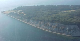
We saw lots of wildlife. There were a good-sized group of pigeon guillemots along the second bluff, to the left. This is, I believe, one of the sites of an on-going study of pigeon guillemots nesting around Puget Sound. They were clearly nesting on the bluffs and hanging out in the water alongside. A little further along, there were a goodly flock of goldfinches perching on the shrubs growing along the top of the bluff, but also fluttering around the cliffs and on the beach. Every couple of hundred yards, there were great blue herons fishing the shore. The stars, though, were the four bald eagles, including a couple of juveniles, sitting on snags along the top of the bluff.
The park runs along the beach below Double Bluff (pictured below), with views of the Olympics (I think – it was cloudy) and across Admiralty Inlet. The bluffs are tall sandstone and clay banks, pretty classic for Puget Sound, and, in some places, actively eroding. We walked to the point on the left of the photo and then back to the parking lot off the right side of the photo.

We saw lots of wildlife. There were a good-sized group of pigeon guillemots along the second bluff, to the left. This is, I believe, one of the sites of an on-going study of pigeon guillemots nesting around Puget Sound. They were clearly nesting on the bluffs and hanging out in the water alongside. A little further along, there were a goodly flock of goldfinches perching on the shrubs growing along the top of the bluff, but also fluttering around the cliffs and on the beach. Every couple of hundred yards, there were great blue herons fishing the shore. The stars, though, were the four bald eagles, including a couple of juveniles, sitting on snags along the top of the bluff.
June 11, 2006
The Hidden Rainforest
Over the Memorial Day weekend, I led a nice group of Mountaineers up the Bogachiel River for a three day backpack trip. This river flows west out of the north side of the Olympic Mountains. It joins up with the Calawah River just west of the town of Forks and then with the Sol Duc River to form the Quillayute River, which flows into the Pacific a few miles later. It is the least well-known of the rain forest rivers on the peninsula and it is a gem.
The trail follows the river valley for over twenty miles to a pass high in the Olympics. We followed it for fifteen miles of its length. At first, it is a turnpike, wandering through river flats so green you can’t imagine anything any greener. Once you’re into the National Park, you start seeing some big trees, spruces mostly here. The first six miles take you to an interesting trail over Indian Pass to the Calawah River and extensive camping. And lots of big trees – Sitka spruce, red cedar, Douglas fir, cottonwood, and western hemlock – some of them six feet or more in diameter. There are fewer big, mossy maples in this valley than the Hoh valley, so this looks like a more conventional forest, but big. There are a few photos from the trip here.
After the first few miles, the trail starts living up to the description we heard in the Information Center in Forks: rough. This was late May, so there were many creek crossings, few bridges, and quite a bit of muddy trail. There were also many, many trees and limbs down on and across the trail. It wasn’t raining, but it was still damp and the creeks were running, so none of us completed the ten miles to Flapjack Camp with dry feet.
The next day, under damper skies, we followed the trail further, as it roughened into a very narrow track, which occasionally disappeared under small herbs and moss. Four miles from our camp, we reached a shelter and the very fine bridge over the North Fork of the Bogachiel. During this day trip, the river changed from a broad, dynamic flow, sluicing back and forth across a huge gravel bed, to a rushing river, confined to a narrow valley – a canyon in places – and running on a solid rock bed.
On the trail, above Flapjack camp, we spooked a group of a half-dozen of elk. Sometimes, they silently disappear in the woods, but this time they just crashed away. We also saw four (or maybe the same pair, twice) eagles cruising the river. On the way back out, I saw a pileated woodpecker and several dippers. The river terrain around our camp had a lot of evidence of past beaver habitation, but nothing was new. Also near our camp, I saw fresh bear tracks in some clay along the river and coyote tracks in the sand.
This is a wild place.
The trail follows the river valley for over twenty miles to a pass high in the Olympics. We followed it for fifteen miles of its length. At first, it is a turnpike, wandering through river flats so green you can’t imagine anything any greener. Once you’re into the National Park, you start seeing some big trees, spruces mostly here. The first six miles take you to an interesting trail over Indian Pass to the Calawah River and extensive camping. And lots of big trees – Sitka spruce, red cedar, Douglas fir, cottonwood, and western hemlock – some of them six feet or more in diameter. There are fewer big, mossy maples in this valley than the Hoh valley, so this looks like a more conventional forest, but big. There are a few photos from the trip here.
After the first few miles, the trail starts living up to the description we heard in the Information Center in Forks: rough. This was late May, so there were many creek crossings, few bridges, and quite a bit of muddy trail. There were also many, many trees and limbs down on and across the trail. It wasn’t raining, but it was still damp and the creeks were running, so none of us completed the ten miles to Flapjack Camp with dry feet.
The next day, under damper skies, we followed the trail further, as it roughened into a very narrow track, which occasionally disappeared under small herbs and moss. Four miles from our camp, we reached a shelter and the very fine bridge over the North Fork of the Bogachiel. During this day trip, the river changed from a broad, dynamic flow, sluicing back and forth across a huge gravel bed, to a rushing river, confined to a narrow valley – a canyon in places – and running on a solid rock bed.
On the trail, above Flapjack camp, we spooked a group of a half-dozen of elk. Sometimes, they silently disappear in the woods, but this time they just crashed away. We also saw four (or maybe the same pair, twice) eagles cruising the river. On the way back out, I saw a pileated woodpecker and several dippers. The river terrain around our camp had a lot of evidence of past beaver habitation, but nothing was new. Also near our camp, I saw fresh bear tracks in some clay along the river and coyote tracks in the sand.
This is a wild place.
June 10, 2006
It Happens Every Time
I’m a soccer fan, but I don’t devote much time to following sports. And, frankly, following soccer – well, let’s just call it football, shall we? – in this country isn’t really cost-effective. So, I mostly reserve my sports watching time for a quadrennial immersion in the World Cup.
One of the frustrations of preparing for this event is the poor quality of the coverage of the sport available in my usual media, which are newspapers and radio. There’s one particular sore point: the obligatory “I don’t like or understand soccer, but I have to write something about the World Cup (it is, after all, the biggest sporting event in the world this year), so I’ll just write about how I don’t like or understand soccer and my editor will print it, just as it is” story.
It happens every time. It annoys me out of all proportion to the magnitude of the crime, I know. Still, the aggressive and stubborn ignorance – this from a professional observer of sport – just ticks me off. It seems just too American, if I may risk saying it. The sport wasn’t invented here, so it’s just out of tune with the “American character” (whatever that is). Blah, blah, blah.
I don’t understand why the writers can’t just do their jobs, which is to learn about things and tell us about them. (Now that I write those words, I realize how utopian they sound, considering the kinds of reporting we have received about rather more important issues over the last few years.)
This year, I was lulled into a false sense of security, because I’d gotten all the way to opening day of the tournament without seeing one of those articles. Then, I got the one-two punch.
The first was the weekly talk on KPLU with their sports writer, Art Thiel. Now, Mr. Thiel is entitled to his opinion, but still, this was an “I don’t like or understand soccer…” story, without a doubt. So, KPLU will do one story on the World Cup and this is it? This is the most important thing about the World Cup, that Art Theil doesn’t like soccer because the players can’t use their hands, so the action isn’t as precise as it is in other sports? Good grief.
So, that got me straightened up and ready for the second punch, supplied, as is traditional, by the Olympian. In the past, this paper has been a reliable purveyor of this kind of nonsense, but I was beginning to think that they’d moved on. Not so. This was actually the lamest of these kinds of stories that I’d ever read. The writer spent her refined product of clear-cut forest on wandering around town trying to find (or trying to not-find) someone who was interested in the World Cup. This, in answer to her self-asked question: “Why people care to watch the World Cup.” She finishes the story practically boasting of her ignorance of the game and the players.
Fortunately, there are some media outlets who don’t take their responsibility to know nothing more than the conventional and to learn nothing beyond that and, certainly, never, ever try to inform us about anything foreign. One of those is the fine blogging of the World Cup by a couple of writers for the New York Times.
For the games themselves, I thank the Tivo I cleverly bought my wife for Christmas.
One of the frustrations of preparing for this event is the poor quality of the coverage of the sport available in my usual media, which are newspapers and radio. There’s one particular sore point: the obligatory “I don’t like or understand soccer, but I have to write something about the World Cup (it is, after all, the biggest sporting event in the world this year), so I’ll just write about how I don’t like or understand soccer and my editor will print it, just as it is” story.
It happens every time. It annoys me out of all proportion to the magnitude of the crime, I know. Still, the aggressive and stubborn ignorance – this from a professional observer of sport – just ticks me off. It seems just too American, if I may risk saying it. The sport wasn’t invented here, so it’s just out of tune with the “American character” (whatever that is). Blah, blah, blah.
I don’t understand why the writers can’t just do their jobs, which is to learn about things and tell us about them. (Now that I write those words, I realize how utopian they sound, considering the kinds of reporting we have received about rather more important issues over the last few years.)
This year, I was lulled into a false sense of security, because I’d gotten all the way to opening day of the tournament without seeing one of those articles. Then, I got the one-two punch.
The first was the weekly talk on KPLU with their sports writer, Art Thiel. Now, Mr. Thiel is entitled to his opinion, but still, this was an “I don’t like or understand soccer…” story, without a doubt. So, KPLU will do one story on the World Cup and this is it? This is the most important thing about the World Cup, that Art Theil doesn’t like soccer because the players can’t use their hands, so the action isn’t as precise as it is in other sports? Good grief.
So, that got me straightened up and ready for the second punch, supplied, as is traditional, by the Olympian. In the past, this paper has been a reliable purveyor of this kind of nonsense, but I was beginning to think that they’d moved on. Not so. This was actually the lamest of these kinds of stories that I’d ever read. The writer spent her refined product of clear-cut forest on wandering around town trying to find (or trying to not-find) someone who was interested in the World Cup. This, in answer to her self-asked question: “Why people care to watch the World Cup.” She finishes the story practically boasting of her ignorance of the game and the players.
Fortunately, there are some media outlets who don’t take their responsibility to know nothing more than the conventional and to learn nothing beyond that and, certainly, never, ever try to inform us about anything foreign. One of those is the fine blogging of the World Cup by a couple of writers for the New York Times.
For the games themselves, I thank the Tivo I cleverly bought my wife for Christmas.
June 8, 2006
Hang up and Drive
I walk along a busy arterial on the way to and from work and have done so for a couple of years, now. Lots of people are talking on their cell phones while they’re driving and it seems to gotten worse.
I made a casual count a couple of years ago and the number of people who passed me on the road while using a cell phone was 3 to 5% of the drivers. This time, I thought I’d be a little more precise.
I counted along Cooper Point Road from the intersection with Evergreen Pk Dr, near the freeway, north and west through the Auto Mall, across Black Lake, along Yauger Park, across Harrison, and north as far as 14th Ave. – about 2.5 miles. I started between five and ten minutes to 5:00 PM and finished about 40 minutes later. I did this twice, yesterday and last Thursday.
I counted all the cars traveling in my direction, including the commercial vehicles, but skipping the buses and motorcycles. There were a few drivers I couldn’t see, either because the car was behind another or had tinted windows. I didn’t count those.
Out of 1280 cars counted, 115 were being driven past me by people using their cell phones. That’s 9%, significantly more than a couple of years ago.
Too many, in my opinion.
I made a casual count a couple of years ago and the number of people who passed me on the road while using a cell phone was 3 to 5% of the drivers. This time, I thought I’d be a little more precise.
I counted along Cooper Point Road from the intersection with Evergreen Pk Dr, near the freeway, north and west through the Auto Mall, across Black Lake, along Yauger Park, across Harrison, and north as far as 14th Ave. – about 2.5 miles. I started between five and ten minutes to 5:00 PM and finished about 40 minutes later. I did this twice, yesterday and last Thursday.
I counted all the cars traveling in my direction, including the commercial vehicles, but skipping the buses and motorcycles. There were a few drivers I couldn’t see, either because the car was behind another or had tinted windows. I didn’t count those.
Out of 1280 cars counted, 115 were being driven past me by people using their cell phones. That’s 9%, significantly more than a couple of years ago.
Too many, in my opinion.
Break Too Long
No good excuse for the long break. I’m sorry to have disappointed my reader, but I’m ready to go again.
May 25, 2006
Walking Outside
In an earlier post, I described some of the experience of walking to work and back. The first thing that I described was dealing with the weather, because that’s first thing that people ask about, but I wanted to make a larger point. It’s not just the weather, but the exposure to the outside, especially compared to driving in a car, that makes the walk different from the drive.
We’re so used to being protected by our cars when we travel that I think there’s a distinct feeling of exposure when we’re out of our cars. The weather – especially the rain and wind – is the most obvious and most easily talked about aspect of being outside. But there’s more. For one thing, people see you out on the sidewalks – anonymity is more assured if you’re in your car. I occasionally have people tell me that they’ve seen me walking to or from work. For another, there are more potential interactions with strangers, someone who falls into stride with you or whom you meet when you stop at a crosswalk. There’s a greater potential of coming face to face with a stranger on foot, even when there are very few people out, than there is in a car in heavy traffic. I think that some people would consider that a problem or a danger.
Ultimately, that exposure is part of what I like about the walk. I think it’s part of what I like about hiking, too, that it gets me out. I like the feeling of freedom that moving about the world on my own two feet brings me.
We’re so used to being protected by our cars when we travel that I think there’s a distinct feeling of exposure when we’re out of our cars. The weather – especially the rain and wind – is the most obvious and most easily talked about aspect of being outside. But there’s more. For one thing, people see you out on the sidewalks – anonymity is more assured if you’re in your car. I occasionally have people tell me that they’ve seen me walking to or from work. For another, there are more potential interactions with strangers, someone who falls into stride with you or whom you meet when you stop at a crosswalk. There’s a greater potential of coming face to face with a stranger on foot, even when there are very few people out, than there is in a car in heavy traffic. I think that some people would consider that a problem or a danger.
Ultimately, that exposure is part of what I like about the walk. I think it’s part of what I like about hiking, too, that it gets me out. I like the feeling of freedom that moving about the world on my own two feet brings me.
May 21, 2006
American Chestnut Trees Found
This is wonderful news:
ABC News: Rare American Chestnut Trees Discovered: A stand of American chestnut trees that somehow escaped a blight that killed off nearly all their kind in the early 1900s has been discovered along a hiking trail not far from President Franklin D. Roosevelt's Little White House at Warm Springs.The woods that we have around here are totally different from those in which the chestnut lives and I've spent little time in those eastern forests. But I can imagine what it would do to the woods I love to have a key member disappear. It would be like losing all of the western hemlock from our woods.
May 20, 2006
Walking to Work
I walk to work as many days as I can. It’s about a three mile trip and takes me just under an hour. I’ve been doing this for about two years. As exercise, it replaces the jogging I did in the middle of the day. But, I also walk to reduce the number of miles I drive, for the social and environmental benefits that creates. Before I went to work on the West Side, I worked at the Capitol Campus. I lived almost to the crest of the Harrison hill, so that walk was shorter than the one I now have. I walked to work most of the time in those days. Walking to work, as an experience, is quite different from using a car.
The first thing that people mention when we talk about the walk is the weather. While I carry some gear to help with the weather, experiencing it is one of the things that I like about walking. Now, we don’t have very dangerous weather around here and it’s really severe only a few times a year, so, generally, the weather is a problem only if you think it is. I like it.
For me, the thing that most influences what the walk is like is the separation from the traffic. It won’t come as a revelation to anyone that our streets are built for cars, not people walking. And a lot of those streets don’t provide pedestrians enough separation from the cars for comfort. Separation can be vertical, like a curb, horizontal distance, or structures, like a barrier. My usual route to work provides a range of separations, from almost nothing (a narrow bike lane with no curb and a ten foot drop at the edge), to all three, as when I walk down a walkway through an empty strip mall.
The second factor that provides annoyance is, of course, the traffic – how many cars there are, how fast they’re going, and how much attentive the drivers are. Separation, of course, insulates one from traffic, so these factors diminish as separation increases. Still, there are times when there is no separation, most often when I have to cross the street. I’ve been pleasantly surprised by how easy it’s been to cross the streets, including the busiest intersection in town. Except for some folks turning right, I’ve had very few troubles at intersections, which is a big improvement from when I jogged on these same streets. Traffic has an influence on the walk even when I’m not crossing it. Walking against traffic along Cooper Point in the afternoon is unpleasant. The sidewalk is not very wide, there’s no strip between the sidewalk and the curb, the traffic is heavy and it’s traveling at 35, most of the time. I generally avoid that route.
One of the advantages of walking is that you see your town differently, in more detail. And some parts of town are more interesting, more pleasant to walk through. None of the routes I have to work are unpleasant in the sense of being dirty or dangerous, but some are more interesting than others. The walk I used to do over the Fourth Ave. Bridge and through downtown was most interesting. Even though the traffic was bad and the separation worse, the bridge was a high point, because of the views out over the bay and the waves of migrating birds passing through spring and fall. The walk I now do doesn’t have the interest of the bridge and downtown, but it still has some features. The most important is that I have several routes to choose from. Some of them pass through alleys, which are mellow and interesting. The part of the walk that skirts the mall, above Yauger Park, offers a good vista of the Black Hills and any approaching weather.
And walking offers the best chance to see some birds and animals. The bridge, as I mentioned before, offered a regular series of migratory birds as they passed through. Last year, I saw a set of four raccoons working their way down by the mall toward Yauger Park. Earlier this year, I saw another crossing Cooper Point Rd. ahead of me. The alleys usually, if the weather’s good, offer the chance to see a few cats lounging in the sun. I regularly see rabbits near my work and around Percival Creek. A run-off retention pond by the Auto Mall supported a redwing blackbird for several years, though he seems to have moved on this year. There were a couple of killdeer hanging around that same pond, more recently. And, the skies sometimes offer a glimpse of a hawk or an eagle soaring overhead, if you only look up.
It’s a lot easier to look up if you’re not in your car. And it’s easier to stop and stare if you’re not in traffic.
The first thing that people mention when we talk about the walk is the weather. While I carry some gear to help with the weather, experiencing it is one of the things that I like about walking. Now, we don’t have very dangerous weather around here and it’s really severe only a few times a year, so, generally, the weather is a problem only if you think it is. I like it.
For me, the thing that most influences what the walk is like is the separation from the traffic. It won’t come as a revelation to anyone that our streets are built for cars, not people walking. And a lot of those streets don’t provide pedestrians enough separation from the cars for comfort. Separation can be vertical, like a curb, horizontal distance, or structures, like a barrier. My usual route to work provides a range of separations, from almost nothing (a narrow bike lane with no curb and a ten foot drop at the edge), to all three, as when I walk down a walkway through an empty strip mall.
The second factor that provides annoyance is, of course, the traffic – how many cars there are, how fast they’re going, and how much attentive the drivers are. Separation, of course, insulates one from traffic, so these factors diminish as separation increases. Still, there are times when there is no separation, most often when I have to cross the street. I’ve been pleasantly surprised by how easy it’s been to cross the streets, including the busiest intersection in town. Except for some folks turning right, I’ve had very few troubles at intersections, which is a big improvement from when I jogged on these same streets. Traffic has an influence on the walk even when I’m not crossing it. Walking against traffic along Cooper Point in the afternoon is unpleasant. The sidewalk is not very wide, there’s no strip between the sidewalk and the curb, the traffic is heavy and it’s traveling at 35, most of the time. I generally avoid that route.
One of the advantages of walking is that you see your town differently, in more detail. And some parts of town are more interesting, more pleasant to walk through. None of the routes I have to work are unpleasant in the sense of being dirty or dangerous, but some are more interesting than others. The walk I used to do over the Fourth Ave. Bridge and through downtown was most interesting. Even though the traffic was bad and the separation worse, the bridge was a high point, because of the views out over the bay and the waves of migrating birds passing through spring and fall. The walk I now do doesn’t have the interest of the bridge and downtown, but it still has some features. The most important is that I have several routes to choose from. Some of them pass through alleys, which are mellow and interesting. The part of the walk that skirts the mall, above Yauger Park, offers a good vista of the Black Hills and any approaching weather.
And walking offers the best chance to see some birds and animals. The bridge, as I mentioned before, offered a regular series of migratory birds as they passed through. Last year, I saw a set of four raccoons working their way down by the mall toward Yauger Park. Earlier this year, I saw another crossing Cooper Point Rd. ahead of me. The alleys usually, if the weather’s good, offer the chance to see a few cats lounging in the sun. I regularly see rabbits near my work and around Percival Creek. A run-off retention pond by the Auto Mall supported a redwing blackbird for several years, though he seems to have moved on this year. There were a couple of killdeer hanging around that same pond, more recently. And, the skies sometimes offer a glimpse of a hawk or an eagle soaring overhead, if you only look up.
It’s a lot easier to look up if you’re not in your car. And it’s easier to stop and stare if you’re not in traffic.
Mt Zion
I went hiking this morning with a group of Mountaineers hike leaders, organized by Eric as a way to get to know each other better and share ideas about leading hikes. Considered against that criterion, I’d call it a success. As a hike, it was also good, but there were no views at the top.
The hike is in the Olympic National Forest, in the northeast corner, east of Quilcene, about 85 road miles from the Forest headquarters in Olympia. It’s a short hike of about 1.8 miles and 1300’ gain to the top of a small peak with views all around. Mt. Zion hosted a fire lookout until 1975. I could only believe our leader when he said that there are views of the northern Cascades, Mt. Baker, the Straits, and Vancouver Island from the top. Today, there was nothing but clouds. Still, the air was still and it wasn’t cold, so we lingered on top for over an hour.
The wild rhododendrons were blooming extravagantly along the road, between the Big Quilcene bridge and Quilcene. Higher, at the trailhead and along the trail, there were numerous rhodies, but they were not yet blooming. We saw a lot of trillium, some tiny, yellow violets, a few Calypso orchids, and red gooseberries blooming. One chipmunk patrolled the summit at lunchtime.
The best part of the day was to hike with some of the best hikers I know. Usually, of course, we’re off leading our own hikes. We don’t very often get a chance to hike together. I think this kind of trip will help to make the hiking program stronger.
The hike is in the Olympic National Forest, in the northeast corner, east of Quilcene, about 85 road miles from the Forest headquarters in Olympia. It’s a short hike of about 1.8 miles and 1300’ gain to the top of a small peak with views all around. Mt. Zion hosted a fire lookout until 1975. I could only believe our leader when he said that there are views of the northern Cascades, Mt. Baker, the Straits, and Vancouver Island from the top. Today, there was nothing but clouds. Still, the air was still and it wasn’t cold, so we lingered on top for over an hour.
The wild rhododendrons were blooming extravagantly along the road, between the Big Quilcene bridge and Quilcene. Higher, at the trailhead and along the trail, there were numerous rhodies, but they were not yet blooming. We saw a lot of trillium, some tiny, yellow violets, a few Calypso orchids, and red gooseberries blooming. One chipmunk patrolled the summit at lunchtime.
The best part of the day was to hike with some of the best hikers I know. Usually, of course, we’re off leading our own hikes. We don’t very often get a chance to hike together. I think this kind of trip will help to make the hiking program stronger.
May 16, 2006
Young Female Osprey M-48905 'Mirja'
This is a very cool site, showing the travels of a young osprey over several years of migrations between Finland and West Africa. It's updated regularly. Mirja is now hanging out around Lake Lagoda, north of St. Petersburg. Apparently, there's some fuss in Finland about how "their" osprey has been hanging out in Russia.
Finnish Museum of Natural History: On 2 July 2002 in Hauho, Ilmoila, in Hame, Tero Niskanen ringed three Osprey fledglings. The youngest, M-48905, was recaptured at the nest on 31 August, when she was observed to be a female weighing 1810 g, and she was named 'Mirja'. At this time, Mirja had already been fully fledged for over three weeks. She was fitted with a solar-powered transmitter weighing 30 g (manufactured by Microwave).The Google map of the spring migration is particularly cool. It's amazing to me that the tracking device can "talk" to the researchers over thousands of miles and that it has lasted several years.
May 13, 2006
Wooden Boat Fair
Believe me, my young friend, there is NOTHING--absolute nothing--half so much worth doing as simply messing about in boats.I spent a couple of hours on Percival Landing at the Wooden Boat Fair this afternoon. For several reasons, I don’t get down there very often, so I was glad to have the chance this weekend – and that the weather was as nice as it was. (It isn’t always nice at all, this time of year.)The Water Rat, Wind in the Willows
I have to admit a weakness for small boats, though I’ve managed to avoid getting sucked into owning one very often. For a long time, I was able to mooch a boat fix off of friends and acquaintances, but that hasn’t worked well at all for a long time. It’s a big step, in terms of time commitment, to go from an occasional day-sail to being responsible for a boat.
Most of the boats on display at the Fair are medicine far too powerful for the paltry boat-weakness that I’m infected with. Still, they are often very beautiful and the people who keep them looking that way are candidates for a certain kind of sainthood in my book.
There were two highlights for me. The first is the Sand Man, which just gets to looking better and better. The last time I saw it was on blocks over at Swantown Marina, with its deckhouse sitting on the pavement. Now, it’s floating and looking pretty. They had the engine running while I was on it and it sounded very good: smooth, relaxed, and powerful. The Sand Man Foundation has done a wonderful job with this relic of an older Olympia.
The other is that the Grapeview Point Boat Works had an array of small, wooden boats in classic designs. There was a beautiful Caledonia yawl, a cute little peapod-type with a lug sail, and a Shellback dinghy. I was pleased that a local builder had brought some new work to show off, in amongst the classic Monks and Gearys.
Almost enough to get me on the water again. Here are a couple of other interesting little boats. The first is a little sailing dinghy. I hope I look as good at its age; it was built in 1937.

The second is the cutest tug I've ever seen. It's only 14 feet long.
May 11, 2006
Human Cargo
I recently read Caroline Moorehead’s book Human Cargo, A Journey Among Refugees. I still haven’t absorbed all that there is in the book, I think because she writes it as the journalist that she is. She just tells the stories. And, since these stories are about human beings, they don’t lend themselves to easy answers or quick solutions. She begins with a brisk history of the modern human rights movement, starting with the founding of the Red Cross in the nineteenth century, and traces its development through the crisis created by the tens of millions of displaced people in Europe after the Second World War to the present structures of asylum policies, refugee camps, and human smuggling.
The core of the book is a survey of the issues and situations suffered by refugees throughout the world. One describes a group of African asylum seekers, whose boat crashed on the coast of Sicily. At first, the local people, full of sympathy for the refugees, many of whom died in the crash, embraced them and helped them get settled and even found them a little work and support. Over time, though, the situation got more complex, for a whole set of reasons: the refugees’ ambiguous legal status, the limited opportunities for them in this poor section of Italy, the barrier of language difference, and post-traumatic stress.
Another describes the draconian measures taken in Australia to control the influx of refugees, many fleeing the wars Afghanistan and Iraq. These included turning ships away along the coast, even if they were in danger of sinking, locking people up in prisons under deplorable conditions, and arbitrary acceptance policies that, in practice, amount to psychological torture. She also describes the plight of asylum seekers who make it to Great Britain and then find themselves dispersed across the country, isolated from others who share their situation and almost totally without support.
The most harrowing chapters deal with the long-term refugee camps in Guinea and the Palestinian camps in Lebanon. Guinea, a neighbor to Ivory Coast and Liberia, has received waves of refugees from those countries over decades. The squalor and hopelessness and rock-bottom poverty of these camps is heart-breaking. Equally so, the plight of the Palestinians, dispossessed during the Naqba, or “disaster” of 1948, and repeatedly brutalized, attacked, moved, and discriminated against in the years since.
The last stories that she tells are some relief, though they are not without their poignancy and pain. With the removal of the Taliban from power in Afghanistan and the renewal of hope that the decades of civil war could end, the country experienced a dramatic influx of its citizens from refuges around the world, though mostly from Iran and Pakistan. The hope and energy that these returning refugees bring to the country, still suffering and struggling, offer some evidence that dispossession can be reversed. The final story is about a cohort of Dinka, from the Sudan, who have settled in north of Finland. They, obviously, have had struggles with adjustment, not the least with the cold and the long nights in winter. But the Finns have worked hard to support their new citizens, have made adjustments, and achieved some success. This offers some additional evidence that, if people can’t go home again, it is possible, with the right policies and resources and neighbors and attitude, for them to make a new life, in a new land.
It was nothing but an accident that this latest immigration fuss erupted while I was reading it. It was timely, however, as an antidote to the simplistic and inhumane terms of the discussion. By contrast, this account is a humane, layered, complex, and clear-eyed look at what happens to people when, for any number of reasons, they are unable to stay in their homes.
The core of the book is a survey of the issues and situations suffered by refugees throughout the world. One describes a group of African asylum seekers, whose boat crashed on the coast of Sicily. At first, the local people, full of sympathy for the refugees, many of whom died in the crash, embraced them and helped them get settled and even found them a little work and support. Over time, though, the situation got more complex, for a whole set of reasons: the refugees’ ambiguous legal status, the limited opportunities for them in this poor section of Italy, the barrier of language difference, and post-traumatic stress.
Another describes the draconian measures taken in Australia to control the influx of refugees, many fleeing the wars Afghanistan and Iraq. These included turning ships away along the coast, even if they were in danger of sinking, locking people up in prisons under deplorable conditions, and arbitrary acceptance policies that, in practice, amount to psychological torture. She also describes the plight of asylum seekers who make it to Great Britain and then find themselves dispersed across the country, isolated from others who share their situation and almost totally without support.
The most harrowing chapters deal with the long-term refugee camps in Guinea and the Palestinian camps in Lebanon. Guinea, a neighbor to Ivory Coast and Liberia, has received waves of refugees from those countries over decades. The squalor and hopelessness and rock-bottom poverty of these camps is heart-breaking. Equally so, the plight of the Palestinians, dispossessed during the Naqba, or “disaster” of 1948, and repeatedly brutalized, attacked, moved, and discriminated against in the years since.
The last stories that she tells are some relief, though they are not without their poignancy and pain. With the removal of the Taliban from power in Afghanistan and the renewal of hope that the decades of civil war could end, the country experienced a dramatic influx of its citizens from refuges around the world, though mostly from Iran and Pakistan. The hope and energy that these returning refugees bring to the country, still suffering and struggling, offer some evidence that dispossession can be reversed. The final story is about a cohort of Dinka, from the Sudan, who have settled in north of Finland. They, obviously, have had struggles with adjustment, not the least with the cold and the long nights in winter. But the Finns have worked hard to support their new citizens, have made adjustments, and achieved some success. This offers some additional evidence that, if people can’t go home again, it is possible, with the right policies and resources and neighbors and attitude, for them to make a new life, in a new land.
It was nothing but an accident that this latest immigration fuss erupted while I was reading it. It was timely, however, as an antidote to the simplistic and inhumane terms of the discussion. By contrast, this account is a humane, layered, complex, and clear-eyed look at what happens to people when, for any number of reasons, they are unable to stay in their homes.
May 8, 2006
Big Hump on the Duckabush River
Saturday I got out on a hike for the first time in several months. I led a Mountaineers group of six up the Duckabush River over the top of Big Hump and part way down the other side before we turned around. It's one of my favorite trips, I think because the terrain and the woods are so varied.
We gathered the last of the group at Potlatch State Park, which makes a convenient mustering point along Hood Canal. Things were hopping there. The gate was still locked when we got there and there were cars lined up on the road waiting to get in. Within a few minutes of the gate opening, the place was teeming with fisherman. The bigger boat ramp parking lot a few hundred yards up the road was completely full. It wasn't until we passed through Hoodsport on the way back home that I saw the sign that announced the opening of shrimp season that day. It's not often that you see that much activity in Hoodsport.
It was cool and cloudy all day, but the rain hinted at in the forecast didn't appear. The clouds were low enough, however, that the ridgetops mostly didn't appear, either. Still, the charms of this trail aren't so much the views as the woods. It starts with a gradual climb up a few hundred feet to the wilderness boundary and the top of the Little Hump. From there, the trail drops down to the river's level and follows a mostly level course along the rushing river. This stretch shows a lot of evidence of logging long ago -- huge cables, road grades (for a time, the trail follows such a skid road), skid paths to the river, huge stumps. The trees have grown back enough to make a pleasant wood of well-spaced trees and lush undergrowth. The sword ferns were just unrolling their fiddleheads this weekend, revealing that wonderful, light green, the very color of spring.
After about three miles, the trail turns away from the river and begins a steep climb up the Big Hump. It's a good trail, well-graded and solid, but it does have several hundred feet to climb. About half-way, there's a nice view on a smooth rock down the river to Hood Canal, a glimpse of a waterfall across the valley, and hints of the cliffs that the river cuts through from the interior of the Olympics. Near the top, another outcrop offers views, but by this time the slope is slackening, so one's tempted to continue to the top.
Through the whole climb, there are a succession of forest types and ages. We're above the logging activity, but a fire had swept through here some time ago, leaving an interesting mix of ages. There are quite a few quite large Douglas firs, many with fire scars on their trunks. These are attended by a mix of much younger trees, apparently grown since the fire. In other places, there is a more varied mix of big and middle-sized trees, including large western hemlocks and red cedars. Near the top of the Hump, there's a thick stand of little trees, with almost no undergrowth.
We turned around about three-quarters of a mile after Big Hump, at a stream where we ate lunch. The trail continues back down to the river level and a nice campsite (though it is cold much of the year) and goes another ten or fifteen miles into the heart of the Olympics. Nothing but old growth the whole way.
We gathered the last of the group at Potlatch State Park, which makes a convenient mustering point along Hood Canal. Things were hopping there. The gate was still locked when we got there and there were cars lined up on the road waiting to get in. Within a few minutes of the gate opening, the place was teeming with fisherman. The bigger boat ramp parking lot a few hundred yards up the road was completely full. It wasn't until we passed through Hoodsport on the way back home that I saw the sign that announced the opening of shrimp season that day. It's not often that you see that much activity in Hoodsport.
It was cool and cloudy all day, but the rain hinted at in the forecast didn't appear. The clouds were low enough, however, that the ridgetops mostly didn't appear, either. Still, the charms of this trail aren't so much the views as the woods. It starts with a gradual climb up a few hundred feet to the wilderness boundary and the top of the Little Hump. From there, the trail drops down to the river's level and follows a mostly level course along the rushing river. This stretch shows a lot of evidence of logging long ago -- huge cables, road grades (for a time, the trail follows such a skid road), skid paths to the river, huge stumps. The trees have grown back enough to make a pleasant wood of well-spaced trees and lush undergrowth. The sword ferns were just unrolling their fiddleheads this weekend, revealing that wonderful, light green, the very color of spring.
After about three miles, the trail turns away from the river and begins a steep climb up the Big Hump. It's a good trail, well-graded and solid, but it does have several hundred feet to climb. About half-way, there's a nice view on a smooth rock down the river to Hood Canal, a glimpse of a waterfall across the valley, and hints of the cliffs that the river cuts through from the interior of the Olympics. Near the top, another outcrop offers views, but by this time the slope is slackening, so one's tempted to continue to the top.
Through the whole climb, there are a succession of forest types and ages. We're above the logging activity, but a fire had swept through here some time ago, leaving an interesting mix of ages. There are quite a few quite large Douglas firs, many with fire scars on their trunks. These are attended by a mix of much younger trees, apparently grown since the fire. In other places, there is a more varied mix of big and middle-sized trees, including large western hemlocks and red cedars. Near the top of the Hump, there's a thick stand of little trees, with almost no undergrowth.
We turned around about three-quarters of a mile after Big Hump, at a stream where we ate lunch. The trail continues back down to the river level and a nice campsite (though it is cold much of the year) and goes another ten or fifteen miles into the heart of the Olympics. Nothing but old growth the whole way.
May 3, 2006
Intercity Transit: The Verdict
 Thumbs up! I rode to work again today and then downtown for a little after work socializing and then back up the hill to home; all without a hitch. Once I was past the anxiety of missing the bus, I found it less effort than driving (and certainly less than walking).
The system has improved a great deal since I last used it. The buses are new, clean, and comfortable. The routes make sense and integrate well. The drivers are courteous. Not only that, but Intercity Transit does a great deal more than just run buses – they are involved in just about everything transport-related in the county. They have the Dial-A-Lift, vanpools, connections to Pierce Transit, Mason Transit, Grays Harbor, and Sound Transit, and the new downtown shuttle, the Dash.
I walk to work almost half the time and have been driving, alone, the rest. I think I can replace about half of those drives with bus rides.
May 2, 2006
Intercity Transit: The Ride
Prompted by the April brochure, which I blogged a few days ago, I started thinking about actually using the bus. And, today, I did.
I caught the 48 on Cooper Pt Rd near 14th a little before 7:00. I was looking to catch the 44 at the mall and experienced the interesting sensation of watching the 44 leave just as my bus was pulling in. I had wondered if that wouldn't happen, since the schedule had them all leaving at the same time from the mall. Fortunately, the driver was able to call the 44's driver and have him wait.
Because the 44 rolls back over part of the 48's route, I can get off the 48 at Safeway and catch the 44 a few minutes later. I'll do that tomorrow and avoid the anxiety of the too-close connection.
The rest of the trip was uneventful, though interesting. I haven't been on SPSCC's campus in a few years and there are a couple of new buildings. The trip home worked well, too, with a more reasonable connection at the mall in this direction. Each way was about 30 minutes, in comparison to almost 60 minutes for the walk and clothing change at the end.
So, I'll use the bus again tomorrow, as I'm heading downtown for a bit after work and can take the bus home from there, too. Then, back to the walking, which is my default method of commute. For some, perhaps even many, of the other commutes to work, I can use the bus, rather than driving. Right now, I walk to work almost half of the time. If the other half is mostly bus-riding, then I'll be down to only one day a week of driving alone to work.
I caught the 48 on Cooper Pt Rd near 14th a little before 7:00. I was looking to catch the 44 at the mall and experienced the interesting sensation of watching the 44 leave just as my bus was pulling in. I had wondered if that wouldn't happen, since the schedule had them all leaving at the same time from the mall. Fortunately, the driver was able to call the 44's driver and have him wait.
Because the 44 rolls back over part of the 48's route, I can get off the 48 at Safeway and catch the 44 a few minutes later. I'll do that tomorrow and avoid the anxiety of the too-close connection.
The rest of the trip was uneventful, though interesting. I haven't been on SPSCC's campus in a few years and there are a couple of new buildings. The trip home worked well, too, with a more reasonable connection at the mall in this direction. Each way was about 30 minutes, in comparison to almost 60 minutes for the walk and clothing change at the end.
So, I'll use the bus again tomorrow, as I'm heading downtown for a bit after work and can take the bus home from there, too. Then, back to the walking, which is my default method of commute. For some, perhaps even many, of the other commutes to work, I can use the bus, rather than driving. Right now, I walk to work almost half of the time. If the other half is mostly bus-riding, then I'll be down to only one day a week of driving alone to work.
April 30, 2006
Powerhouse Road
There’s a new development on the road along the bluff, through Heritage Park to the powerhouse on Capital Lake. On March 13, The Olympian reported that Ben Livingston had received a $101 ticket for walking on the road. Nothing special about that day, except, perhaps, the State Patrol officer Livingston encountered – hundreds of citizens walk the road daily.
Since then, General Administration has been back-pedaling on the rule under which Livingston was ticketed. They added signs that indicated that pedestrians should yield to vehicles (duh) and should not actually go to the powerhouse. In addition, they added a crosswalk across the road to the hillside trail up to the Temple of Justice.
Yesterday, while walking along the lake trail, I noticed another enhancement in the campaign for clarity: a stripe, the length of the road, indicating a pedestrian zone on the pavement. Now, I think that the rule that reserved the road for vehicles was too much, but if that rule is still in place, then how is a pedestrian lane in the road itself consistent with it?
Since GA has now painted a pedestrian symbol on the road, I hope they let Livingston off the hook for being a pedestrian on the road.
Since then, General Administration has been back-pedaling on the rule under which Livingston was ticketed. They added signs that indicated that pedestrians should yield to vehicles (duh) and should not actually go to the powerhouse. In addition, they added a crosswalk across the road to the hillside trail up to the Temple of Justice.
Yesterday, while walking along the lake trail, I noticed another enhancement in the campaign for clarity: a stripe, the length of the road, indicating a pedestrian zone on the pavement. Now, I think that the rule that reserved the road for vehicles was too much, but if that rule is still in place, then how is a pedestrian lane in the road itself consistent with it?
Since GA has now painted a pedestrian symbol on the road, I hope they let Livingston off the hook for being a pedestrian on the road.
April 28, 2006
Talk About Re-arranging the Deck Chairs!
So, investigators for the Senate Homeland Security and Governmental Affairs Committee have drafted a report in which they recommend that FEMA be dismantled and replaced with another agency with a different name and the same responsibilities. That such a ridiculous and wasteful idea could be seriously proposed to a Senate committee is a measure of how low our expectations for government have fallen after years of assaults on the very idea of government and public service from conservative ideologues.
Paul Krugman has a good outline of the history of FEMA over the last decade and a half:
The critical factor is support, from the administration, for effective government by appointing and supporting competent managers and staff. In the absence of that -- and we can be sure there will be an absence of that with the Decider in office -- there is no reason at all to spent the resources to dismantle one agency, only to replace it with another to do the same thing. We have had an effective FEMA in the past and could have one again, but there's no reason to believe that this administration will do it, so let's stop pretending.
Paul Krugman has a good outline of the history of FEMA over the last decade and a half:
The Crony Fairy - New York Times: "In the early 1990's, FEMA's reputation was as bad as it is today. It was a dumping ground for political cronies, headed by a man whose only apparent qualification for the job was that he was a close friend of the first President Bush's chief of staff. FEMA's response to Hurricane Andrew in 1992 perfectly foreshadowed Katrina: the agency took three days to arrive on the scene, and when it did, it proved utterly incompetent.He's right. The current administration is interested in power, but not in the hard work of governing. Why not? Because they don't value government and don't believe that it delivers public benefit. While many people were disposed to believe the same thing before the Decider was elected, there are a lot more now who've become discouraged by the administration's consistent delivery of ineffective government. Katrina is only one obvious example.
Many people thought that FEMA was a lost cause. But Bill Clinton proved them wrong. He appointed qualified people to lead the agency and gave them leeway to hire other qualified people, and within a year FEMA's morale and performance had soared. For the rest of the Clinton years, FEMA was among the most highly regarded agencies in the federal government.
What happened to that reputation? The answer, of course, is that the second President Bush returned to his father's practices. Once again, FEMA became a dumping ground for cronies, and many of the good people who had come in during the Clinton years left. It took only a few years to transform one of the best agencies in the U.S. government into what Senator Susan Collins calls 'a shambles and beyond repair.'"
The critical factor is support, from the administration, for effective government by appointing and supporting competent managers and staff. In the absence of that -- and we can be sure there will be an absence of that with the Decider in office -- there is no reason at all to spent the resources to dismantle one agency, only to replace it with another to do the same thing. We have had an effective FEMA in the past and could have one again, but there's no reason to believe that this administration will do it, so let's stop pretending.
April 26, 2006
Peter Matthiessen
We drove up to Seattle yesterday evening to hear Peter Matthiessen speak at Benaroya Hall. Both my wife and I have been readers of his work for years. For those not familiar with him, he writes beautiful, thoughtful stories and accounts of the natural world, as well as complex and engrossing fiction. I’ve read At Play in the Fields of the Lord, The Snow Leopard, and Tigers in the Snow. Hearing him talk about the process of writing made me want to read more.
He started with an impassioned appeal for support for continued protection of the Arctic Wildlife Refuge from oil exploitation. In it, he made an interesting point, one I’d not heard anyone make before: that this is the last place in the world with the full Pleistocene fauna (that which is still in existence) – all three North American bears, wolves, wolverines, caribou, musk ox, and birds, millions of birds from all over the world.
The core of his talk was about his career in writing. I found it interesting that a man who has written twice as many non-fiction works as fiction primarily thinks of himself as a fiction writer. He talked about some of the people he’d worked with – his first agent, his editor at the New Yorker – and some of the journeys he’d undertaken to research his stories. A good bit of the time he talked about his three volume novel about a Florida planter and murderer, Edgar Watson, and the process of researching the story over twenty years. It was interesting and entertaining evening. He came across as modest and thoughtful and funny.
He closed with a series of questions from the audience that brought the discussion around to the situation of humans on the planet, in which he described humans as a beautiful and terrible animal. That this life on this earth is a wonderful thing, but he didn’t consider himself optimistic, given our continuing destruction of each other and our shared home.
April 23, 2006
The Swallows Return
This sunny morning, as I retrieved the papers from the driveway, I noted with delight that the violet-green swallows have returned, right on schedule. I love their chattery little calls and their swooping, arcing flight (and the fact that they eat flying insects). Their return is the real start of spring for me.
When I lived on Foote St. (about a mile east of here), the first sunny day after the start of spring was usually the day they appeared in the sky above my front yard. Where I live now, a few blocks north of Grass Lake, west of Cooper Pt. Rd., it takes them another month to show. I’ve no doubt that they arrive much earlier over Grass Lake (though I haven’t investigated this hypothesis). So, here, it’s usually the first sunny day a month after the start of spring.
My wife reported that they have already been in and out of the swallow box on the south side of the house. I cleaned it out about a month ago, as suggested by Ruth Pagel on the TCTV’s Birdwise Magazine show. We’ve had nesting in that box every year for the past five or more, ever since I found that spot for it – shaded from the sun during the heat of the day and sheltered from the rain, but on the warmer, south-facing wall with a lot of flying room around it. I had nesting five years in a row at my Foote St. house, too.
When I lived on Foote St. (about a mile east of here), the first sunny day after the start of spring was usually the day they appeared in the sky above my front yard. Where I live now, a few blocks north of Grass Lake, west of Cooper Pt. Rd., it takes them another month to show. I’ve no doubt that they arrive much earlier over Grass Lake (though I haven’t investigated this hypothesis). So, here, it’s usually the first sunny day a month after the start of spring.
My wife reported that they have already been in and out of the swallow box on the south side of the house. I cleaned it out about a month ago, as suggested by Ruth Pagel on the TCTV’s Birdwise Magazine show. We’ve had nesting in that box every year for the past five or more, ever since I found that spot for it – shaded from the sun during the heat of the day and sheltered from the rain, but on the warmer, south-facing wall with a lot of flying room around it. I had nesting five years in a row at my Foote St. house, too.
April 22, 2006
Intercity Transit: The Brochure
The April edition the IT flyer (PDF here) contains a good history of the system and has some interesting information in graphs. Of the people within the service area, 11% ride the bus once a month or more and another 28% are considered “potential” riders, in that they would consider riding the bus. I suppose I would count myself among those, as I’m already among the reported 24% of commuters at “major worksites” who use an alternative “mode.” I walk the three miles to work and back about every other day and drive alone the rest. I could use the bus for some of those driving days.
When I lived in the north end of Seattle and worked on First Hill and downtown, I rode the bus every day. It worked great, as I was able to read on the way in and nap on the way home, usually waking up before my stop. Unfortunately, I haven’t been able to use IT’s system to such an extent. I learned on my first day of work for the state that I could walk to work from the near west side to the campus in less time than the bus would take. The service has improved a great deal in the intervening years, but I still don’t use the bus much. I did use the old shuttle from the courthouse hill to downtown to take lunch during Lakefair or for meetings on the campus, but that’s about it.
So, I visited IT’s route page to see what it would take to use the bus. For both directions, buses run every thirty minutes. I could catch the 48 after 7:19 and be at the mall at 7:28. Route 44 leaves the mall at 7:28 (one hopes that means a reliable connection and not a just-missed-it event) and arrives at the courthouse at 7:45. That would get me to work in about 25 minutes. Walking takes 45 - 50 and driving takes 10 - 15. Not terrible. A trip home after work would start after 5:07, make a transfer at the mall at 5:28 and drop me near my home before 5:35 for a trip of less than 30 minutes during a busy traffic time. Again, not bad, and only a $1.50.
(Cross-posted at OlyBlog.)
When I lived in the north end of Seattle and worked on First Hill and downtown, I rode the bus every day. It worked great, as I was able to read on the way in and nap on the way home, usually waking up before my stop. Unfortunately, I haven’t been able to use IT’s system to such an extent. I learned on my first day of work for the state that I could walk to work from the near west side to the campus in less time than the bus would take. The service has improved a great deal in the intervening years, but I still don’t use the bus much. I did use the old shuttle from the courthouse hill to downtown to take lunch during Lakefair or for meetings on the campus, but that’s about it.
So, I visited IT’s route page to see what it would take to use the bus. For both directions, buses run every thirty minutes. I could catch the 48 after 7:19 and be at the mall at 7:28. Route 44 leaves the mall at 7:28 (one hopes that means a reliable connection and not a just-missed-it event) and arrives at the courthouse at 7:45. That would get me to work in about 25 minutes. Walking takes 45 - 50 and driving takes 10 - 15. Not terrible. A trip home after work would start after 5:07, make a transfer at the mall at 5:28 and drop me near my home before 5:35 for a trip of less than 30 minutes during a busy traffic time. Again, not bad, and only a $1.50.
(Cross-posted at OlyBlog.)
April 20, 2006
Off the Table
Our president has made a point of boasting about keeping the nuclear option on the table in the trumped up dispute with Iran over their nuclear program. This is nothing but a signal of weakness and most of the world knows it. Unfortunately, the administration doesn't know it.
The use of nuclear weapons in this instance would be a disaster to make the other disasters created or worsened by this administration look like a picnic. Even the threat is counter-productive. Captain Future has a good explanation of this:
The use of nuclear weapons in this instance would be a disaster to make the other disasters created or worsened by this administration look like a picnic. Even the threat is counter-productive. Captain Future has a good explanation of this:
Daily Kos: Not Even As A Bluff: Asked by a reporter on Tuesday if he would take the nuclear option off the table in what action he might take against Iran, President Bush said he would not. Within hours, the price of oil shot up to more than $72 a barrel, as a direct result of such threats.
Bush's refusal to take nuclear attack 'off the table' is received in different ways. But absolutely none of them has a positive outcome.
This brief diary suggest why the so-called nuclear option is a very bad idea, even as a tactic. And why we must insist it be taken off the table now." [There's more...]So, if this bothers you, too, I urge you to contact our representatives and urge them to urge our benighted leaders to come to their senses. Not that this will happen, but it's time for the responsible citizenry to speak up and demand that this reckless and pointless posturing be stopped. Take the nuclear option off the table!
April 19, 2006
Meta
When I started this, I resolved to do as little writing about blogging as possible. I could go on and on about how this might work, or should work, or could, but it wasn’t what I wanted to do here. And, yet, here I am, dissatisfied with what I’ve been able to do: only about an entry a week.
In the first place, I do this at a time of very low energy for me. I can’t say I have a very hard job, but it takes a good part of my creative energy. Most evenings, I don’t feel that I have the push to finish a useful post.
Second, it turns out to be harder to do this in what feels like an empty space. In my other writing, at work, it always feels like I’ve an audience, even when I don’t get any response. I know the people I’m sending whatever it is to. It keeps me on my toes.
Finally, this is just plain harder to do than I thought, going in. It doesn’t help when I read something smoother, funnier, more eloquent, or better informed than I can muster. Thinking it through in preparation, I always imagine the results as so much more effective and interesting than I find when I write them out.
In the first place, I do this at a time of very low energy for me. I can’t say I have a very hard job, but it takes a good part of my creative energy. Most evenings, I don’t feel that I have the push to finish a useful post.
Second, it turns out to be harder to do this in what feels like an empty space. In my other writing, at work, it always feels like I’ve an audience, even when I don’t get any response. I know the people I’m sending whatever it is to. It keeps me on my toes.
Finally, this is just plain harder to do than I thought, going in. It doesn’t help when I read something smoother, funnier, more eloquent, or better informed than I can muster. Thinking it through in preparation, I always imagine the results as so much more effective and interesting than I find when I write them out.
April 15, 2006
Afterlands
I just finished Afterlands, a wonderful novel by Steven Heighton, a poet and novelist. It’s a beautifully-written account of a disastrous expedition to the Arctic and the aftermath of those struggles in the lives of three of the participants. It weaves an incredible and true story of survival, adrift on a chunk of ice through an Arctic winter, into a brilliant imagining of those events and what they created for the survivors. The author tells the events while pulling them through a mesh of conflicts between cultures, languages, nationalisms, class, and more personal commitments.
The first half of the book is the story of the group of nineteen, a mix of whites and Inuit, left adrift on an ice flow in Baffin Bay, while their ship leaves them, never to return. For the next six months, they survive on a slowly shrinking flow of ice, through the Arctic winter, while a slow madness overtakes the entire party. Tyson, the ranking officer of the group, struggles with his doubts and weakness while the party spins apart, rising to the challenge only at the end of the drift, when the flow becomes uninhabitable as it falls apart. Tukulito, the Inuit interpreter, finds her careful separation of her “native” and “white” identities coming apart as starvation and madness pull at the party. And Kruger, one of the several German immigrant seamen on this American expedition, is marooned once again, within the group, as it splits along national and racial lines.
The second half follows mostly the story of Kruger, as he heads south into Mexico, hoping to escape the notoriety that follows the publication of Tyson’s book, in which he is branded a spy and a thief. And, he’s also trying to escape the rationalizations that people use to allow themselves to kill and oppress others. Tukulito finishes her trajectory early, succumbing to tuberculosis a few years after returning, while her husband was away on another Arctic expedition. Tyson finds that acclaim is a poor salve for self-doubt and returns to the Arctic, as well, hoping for a less compromised result.
The first half of the book is the story of the group of nineteen, a mix of whites and Inuit, left adrift on an ice flow in Baffin Bay, while their ship leaves them, never to return. For the next six months, they survive on a slowly shrinking flow of ice, through the Arctic winter, while a slow madness overtakes the entire party. Tyson, the ranking officer of the group, struggles with his doubts and weakness while the party spins apart, rising to the challenge only at the end of the drift, when the flow becomes uninhabitable as it falls apart. Tukulito, the Inuit interpreter, finds her careful separation of her “native” and “white” identities coming apart as starvation and madness pull at the party. And Kruger, one of the several German immigrant seamen on this American expedition, is marooned once again, within the group, as it splits along national and racial lines.
The second half follows mostly the story of Kruger, as he heads south into Mexico, hoping to escape the notoriety that follows the publication of Tyson’s book, in which he is branded a spy and a thief. And, he’s also trying to escape the rationalizations that people use to allow themselves to kill and oppress others. Tukulito finishes her trajectory early, succumbing to tuberculosis a few years after returning, while her husband was away on another Arctic expedition. Tyson finds that acclaim is a poor salve for self-doubt and returns to the Arctic, as well, hoping for a less compromised result.
April 5, 2006
Bullion Basin
I went skiing in Bullion Basin, next to Crystal Mountain on Sunday. It was the most back-country that I’ve skied and I found myself at the limit of my abilities and my equipment. The weather was fine, cloudy-foggy, but not windy or snowy. There was a lot of snow and the route-finding was not too bad, considering I hadn’t been there before.
In fact, it’s been decades since I’d been to Crystal. It is a lot fancier than I remember, but not fancy enough to entice me to stick around for long. I strapped on the sticks and started climbing up the far left-hand side of the little chair at the northeast edge of the groomed area. A combination of road and trail took me to the creek in Bullion Basin and a steep climb gained the open slopes above the creek gulley. It was that climb that began the realization that I was in, not over my head, but near enough that I had to look out.
I tried to follow the tracks of some others who joined me on the trail part way up (climbing up from one of the lower parking lots), but I couldn’t climb steeply enough. My fish-scaled, back-country skis just couldn’t point high enough. (Time to shop for some skins, I’m afraid.) So, for every hundred yards of their trail, I walked a couple hundred. Still, I plugged away and, after a couple of hours, reached the basin at about 5600’.
By that time, I was in a groove, so I followed the tracks (the only tracks through the flat basin) toward the south and up the slope. This one was even steeper and the snow was deeper (about 18” of soft, with no discernable base), so the going was slower. After an hour, I came into the bottom of another open slope, at about 6100’, where the terrain gentled some, and by which time I was beat.
I stamped out a platform, pulled on another layer or three, and sat down to lunch. It was then I finally took a look at the map and realized that I’d missed the route to the ridge top (and the continuation toward Norse Peak to the north) when I’d followed the track south across the basin below. Either the others going to the ridge stayed above the basin, to the north of my route (which is likely) or everyone else just went the same way I did (just a lot more directly). Oh, well, it was a good day in the snow, all the same.
The trip down was much quicker, of course, but it still had its lessons for me. The snow was too deep for me to turn much through it, even up high where it was light. In the lower half, it started to get heavy, making controlled turning even more difficult with free heels. I side-slipped down the creek gulley, ran down the upper trails (which hadn’t seen snow machines, fell once and bent my new pole, and slowly worked my way down the lower road, with its wet snow all churned up by a snow cat.
As much as I like being out and moving about in the mountains in the winter, I’d had just about as much as I could handle that day. I’d call that almost perfect.
In fact, it’s been decades since I’d been to Crystal. It is a lot fancier than I remember, but not fancy enough to entice me to stick around for long. I strapped on the sticks and started climbing up the far left-hand side of the little chair at the northeast edge of the groomed area. A combination of road and trail took me to the creek in Bullion Basin and a steep climb gained the open slopes above the creek gulley. It was that climb that began the realization that I was in, not over my head, but near enough that I had to look out.
I tried to follow the tracks of some others who joined me on the trail part way up (climbing up from one of the lower parking lots), but I couldn’t climb steeply enough. My fish-scaled, back-country skis just couldn’t point high enough. (Time to shop for some skins, I’m afraid.) So, for every hundred yards of their trail, I walked a couple hundred. Still, I plugged away and, after a couple of hours, reached the basin at about 5600’.
By that time, I was in a groove, so I followed the tracks (the only tracks through the flat basin) toward the south and up the slope. This one was even steeper and the snow was deeper (about 18” of soft, with no discernable base), so the going was slower. After an hour, I came into the bottom of another open slope, at about 6100’, where the terrain gentled some, and by which time I was beat.
I stamped out a platform, pulled on another layer or three, and sat down to lunch. It was then I finally took a look at the map and realized that I’d missed the route to the ridge top (and the continuation toward Norse Peak to the north) when I’d followed the track south across the basin below. Either the others going to the ridge stayed above the basin, to the north of my route (which is likely) or everyone else just went the same way I did (just a lot more directly). Oh, well, it was a good day in the snow, all the same.
The trip down was much quicker, of course, but it still had its lessons for me. The snow was too deep for me to turn much through it, even up high where it was light. In the lower half, it started to get heavy, making controlled turning even more difficult with free heels. I side-slipped down the creek gulley, ran down the upper trails (which hadn’t seen snow machines, fell once and bent my new pole, and slowly worked my way down the lower road, with its wet snow all churned up by a snow cat.
As much as I like being out and moving about in the mountains in the winter, I’d had just about as much as I could handle that day. I’d call that almost perfect.
Subscribe to:
Posts (Atom)