It was a great backpack, with a great group.
The first day was more driving than hiking, so we started in the heat of a hot day on the hot side of the mountains. That and the late start meant that we didn’t get to the pass the first day, but found a very nice little camping spot on a small tributary of Buck Creek. There’s a much bigger camp about ten minutes past our site. Besides the heat, the key first impression of this valley is that many of the trees are suffering from some sort of disease, which results in their branch tips are dead or dying. Higher in the valley, around 5000’, this seemed to abate.
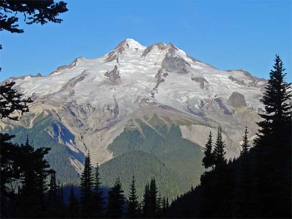
The next day, with an earlier start, we made the pass a little after noon. The trail is very good, with a very steady grade. My old Holden quadrangle (data from 1944, minor corrections in 1968) has the trail following the creek all the way to the pass, but the real (probably new) location is much better, considering the steep terrain and serious slides. Buck Creek Pass is a broad sweep of mixed tree groves and meadow, ranging between 5600 and 5800’, settled between Helmet Butte and liberty Cap. It sits on the Cascade Crest, with volcanic Glacier Peak directly across the Suiattle River valley.
That afternoon, a trio of backpackers rested in our camp’s vicinity. Carl, Gretchen, and Andrew were about half-way through a three week section hike of the Pacific Crest Trail, having started at Stevens Pass, bound for the Canadian border. This was the last section of the Trail, the end of a fourteen year project to hike the entire way. They were looking forward to the laundry at Stehekin the next evening.
Flower Dome is an easy side trip from Buck Creek Pass. It lies just east of the pass and is wrapped with lush, flowering meadows. While walking through one to get a look back at the Pass, I flushed a grouse (which startled the heck out of me, as usual). The top is almost all open meadow and has great views. A few days later a hiker asked if you could camp on Flower Dome and I realized then that you could. There’s lots of room, as long as you carry your water over from Buck Creek Pass. On the way back, I surprised a marmot munching on the meadow plants.
The third day we spent hiking the good trail south, along the crest, almost to High Pass, which offers a route into the Napeequa River drainage. This is a great route. The trail switchbacks up the north side of Liberty Cap, before sliding around the west side, where it traverses through more beautiful meadows around the Cap to a pass to its south. Another meadowy traverse around the next bump on the ridge and then passing onto the east side of the ridge, along steep, rocky slopes, to a third pass. From there, we entered the rock and snow basin between our ridge and High Pass. There’s a beautiful, greenish-blue lake in that basin, which is the source of Triad Creek. One snowfield was a little too firm and a little too steep for the group to be able to get to High Pass, so we settled (if you could call it that) for expansive views to Glacier Peak, massive Clark Mtn., the Entiat range, and assorted other peaks in every direction you could look. On the return, there was fresh smoke arising behind Mt. Fernow, Seven Fingered Jack, and Mt. Maude, just one more fire to add to those still burning in the wilderness to the northeast.
Each afternoon in the pass, we witnessed a major landslide on Glacier Peak, filling Chocolate Creek with a cloud of dust, which then traveled down the valley into the larger Suiattle valley. We returned the next day, hiking out, stopping for dinner in Sultan, and worked the I-5 traffic to home, tired, but satisfied.
No comments:
Post a Comment